
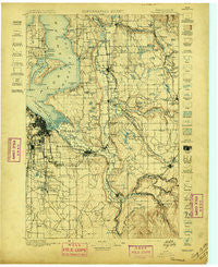
~ Tacoma WA topo map, 1:125000 scale, 30 X 30 Minute, Historical, 1897
Tacoma, Washington, USGS topographic map dated 1897.
Includes geographic coordinates (latitude and longitude). This topographic map is suitable for hiking, camping, and exploring, or framing it as a wall map.
Printed on-demand using high resolution imagery, on heavy weight and acid free paper, or alternatively on a variety of synthetic materials.
Topos available on paper, Waterproof, Poly, or Tyvek. Usually shipping rolled, unless combined with other folded maps in one order.
- Product Number: USGS-5411430
- Free digital map download (high-resolution, GeoPDF): Tacoma, Washington (file size: 10 MB)
- Map Size: please refer to the dimensions of the GeoPDF map above
- Weight (paper map): ca. 55 grams
- Map Type: POD USGS Topographic Map
- Map Series: HTMC
- Map Verison: Historical
- Cell ID: 66747
- Scan ID: 244174
- Survey Year: 1895
- Datum: Unstated
- Map Projection: Unstated
- Map published by United States Geological Survey
- Map Language: English
- Scanner Resolution: 600 dpi
- Map Cell Name: Tacoma
- Grid size: 30 X 30 Minute
- Date on map: 1897
- Map Scale: 1:125000
- Geographical region: Washington, United States
Neighboring Maps:
All neighboring USGS topo maps are available for sale online at a variety of scales.
Spatial coverage:
Topo map Tacoma, Washington, covers the geographical area associated the following places:
- Bethel Park - Harvest Gate Mobile Home Park - Spanaway - Pleasant Valley Manor Mobile Home Park - Sunnydale - Twin Flags Mobile Home Community - Buenna - Meredith - Graham - Whispering Firs Mobile Home Park - Parkwood Lane Mobile Home Park - Rocky Ridge - Country Road Estates Mobile Home Park - Browns Point - Tiger Mountain Mobile Home Park - Cottonwood Mobile Home Park - Tyee Mobile Park - Maury - Elmwood Mobile Home Park - Winchester Village Mobile Home Park - Town and Country Mobile Manor - Evergreen Ridge Mobile Home Park - Lakota - Country Mobile Estates - Deer Run Mobile Home Park - Evansville - Twin Oaks Mobile Home Park - Lone Cedar Mobile Home Park - Mileta - West Hill Mobile Manor - Dieringer - One Hundred Thirty - Eighth Park Mobile Estates - Midland Meadows Mobile Home Park - Don Juan Mobile Home Park - Tall Firs Estates Mobile Home Park - Shady Haven Mobile Home Park - Meridian Heights - Emerald Crest Mobile Home Park - Edgewood - Lake Money Smith Estates Mobile Home Park - Killarney Woods Mobile Home Park - Burien - Three Ponds Mobile Home Park - Viking Mobile Home Court - Adelaide - Alderton - Vantage Glen Mobile Home Park - Star Lake - Lake Desire - Puyallup - Zenith - Valley Mobile Manor - Auburn Hills Mobile Home Park - Shady Woods East and West Mobile Home Park - Highline - Jovita - Klahanie - Midway Mobile Mansions - Wilkeson Gardens Mobile Home Park - Orchard Trailer Park - Berrydale - Kloshe Illahee Mobile Home Park - Ohana Estates Mobile Home Park - Majestic Mobile Manor - Belmor Mobile Home Park - North Hill - View Crest Mobile Manor - Evergreen Manor Mobile Home Park - Cebalop (historical) - Skylark Village Mobile Home Park - Cherrywood Mobile Home Manor Sewage Treatment Plant - Camelot Square Mobile Home Park - Orting - Green Meadows Family Mobile Home Park - Midland - Summerville Estates Mobile Home Park - Hongking (historical) - Double A Mobile Manor - Harvard View Mobile Home Park - Miller's Villa Mobile Home Park - Leisure Manor Mobile Community - Cedar Mountain - Rhododendron Mobile Home Park - Francis Mobile Home Court - Sound Vista Mobile Home Park - Central Valley Mobile Home Park - Orillia - Country West Mobile Home Park - Monta Vista - Canyon Glen Mobile Home Park - Greenwood Mobile Home Park - Park Place Estates Manufactured Home Park - Mirror Lake - Wonderland Mobile Homes - Atkinson - Shilo Mobile Home Park - Arcadia - Cherokee Bay Park - Evergreen Acres Mobile Home Park - Cowley
- Map Area ID: AREA47.547-122.5-122
- Northwest corner Lat/Long code: USGSNW47.5-122.5
- Northeast corner Lat/Long code: USGSNE47.5-122
- Southwest corner Lat/Long code: USGSSW47-122.5
- Southeast corner Lat/Long code: USGSSE47-122
- Northern map edge Latitude: 47.5
- Southern map edge Latitude: 47
- Western map edge Longitude: -122.5
- Eastern map edge Longitude: -122


