
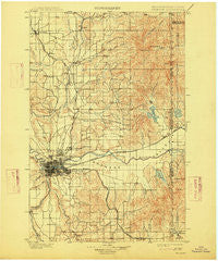
~ Spokane WA topo map, 1:125000 scale, 30 X 30 Minute, Historical, 1901, updated 1915
Spokane, Washington, USGS topographic map dated 1901.
Includes geographic coordinates (latitude and longitude). This topographic map is suitable for hiking, camping, and exploring, or framing it as a wall map.
Printed on-demand using high resolution imagery, on heavy weight and acid free paper, or alternatively on a variety of synthetic materials.
Topos available on paper, Waterproof, Poly, or Tyvek. Usually shipping rolled, unless combined with other folded maps in one order.
- Product Number: USGS-5411380
- Free digital map download (high-resolution, GeoPDF): Spokane, Washington (file size: 9 MB)
- Map Size: please refer to the dimensions of the GeoPDF map above
- Weight (paper map): ca. 55 grams
- Map Type: POD USGS Topographic Map
- Map Series: HTMC
- Map Verison: Historical
- Cell ID: 66672
- Scan ID: 243947
- Imprint Year: 1915
- Edit Year: 1911
- Survey Year: 1898
- Datum: Unstated
- Map Projection: Unstated
- Map published by United States Geological Survey
- Map Language: English
- Scanner Resolution: 600 dpi
- Map Cell Name: Spokane
- Grid size: 30 X 30 Minute
- Date on map: 1901
- Map Scale: 1:125000
- Geographical region: Washington, United States
Neighboring Maps:
All neighboring USGS topo maps are available for sale online at a variety of scales.
Spatial coverage:
Topo map Spokane, Washington, covers the geographical area associated the following places:
- Millwood - Velox - Colbert - Alpha (historical) - Opportunity - Vera - Austin - Dishman - Moab - Parkwater - Pasadena Park - Milan - Geiger Heights - Valleyford - Liberty Lake - Buckeye - Spokane Valley - Chnak'wa'qn Breaks - Duncan - Town and Country - West Spokane - Dartford - Mica - Hamann Corner - Denison - Newman Lake - Pleasant View - Orchard Prairie - Orchard Park - Chatnwaqhi'łpm Grove - Chester - Glenrose - Yardley - Orchard Avenue - Ne'sqhwaqhwe (historical) - State Line Village - Freeman - East Farms - Trentwood - Veradale - Chattaroy - Spokane - Hillyard - Mead - Deer Park - Green Bluff - Marshall - Irwin - Greenacres - Hutton Settlement - Country Homes - Manito - East Spokane - Peone - Fairwood - T Bridge Corner - Otis Orchards - Hauser
- Map Area ID: AREA4847.5-117.5-117
- Northwest corner Lat/Long code: USGSNW48-117.5
- Northeast corner Lat/Long code: USGSNE48-117
- Southwest corner Lat/Long code: USGSSW47.5-117.5
- Southeast corner Lat/Long code: USGSSE47.5-117
- Northern map edge Latitude: 48
- Southern map edge Latitude: 47.5
- Western map edge Longitude: -117.5
- Eastern map edge Longitude: -117


