
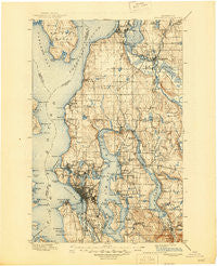
~ Snohomish WA topo map, 1:125000 scale, 30 X 30 Minute, Historical, 1897, updated 1945
Snohomish, Washington, USGS topographic map dated 1897.
Includes geographic coordinates (latitude and longitude). This topographic map is suitable for hiking, camping, and exploring, or framing it as a wall map.
Printed on-demand using high resolution imagery, on heavy weight and acid free paper, or alternatively on a variety of synthetic materials.
Topos available on paper, Waterproof, Poly, or Tyvek. Usually shipping rolled, unless combined with other folded maps in one order.
- Product Number: USGS-5411356
- Free digital map download (high-resolution, GeoPDF): Snohomish, Washington (file size: 10 MB)
- Map Size: please refer to the dimensions of the GeoPDF map above
- Weight (paper map): ca. 55 grams
- Map Type: POD USGS Topographic Map
- Map Series: HTMC
- Map Verison: Historical
- Cell ID: 66651
- Scan ID: 243817
- Imprint Year: 1945
- Survey Year: 1895
- Datum: Unstated
- Map Projection: Polyconic
- Map published by United States Geological Survey
- Map Language: English
- Scanner Resolution: 600 dpi
- Map Cell Name: Snohomish
- Grid size: 30 X 30 Minute
- Date on map: 1897
- Map Scale: 1:125000
- Geographical region: Washington, United States
Neighboring Maps:
All neighboring USGS topo maps are available for sale online at a variety of scales.
Spatial coverage:
Topo map Snohomish, Washington, covers the geographical area associated the following places:
- Mountlake Terrace - Belltown - Valley View Mobile Manor - Roxbury Heights - Westward Mobile Park - Northgate - Issaquah - Phinney Ridge - Casino Corner - Twin Creek Mobile Home Park - Sunlight Beach - Thrashers Corner - Roosevelt - Holly Hills Mobile Home Park - Fremont - Coal Creek - Fairway Estates Senior Mobile Home Park - Airport Inn Mobile Home Park - Kenwood - Somerset - Holly Park - Pine Lake - Sammamish - Ashwood - Martha Lake - May Creek - Kenilworth - Bromart - Haller Lake - Whittier Heights - Sand Point - Olympic Hills - Hillman City (historical) - Shady Lawn Mobile Home Park - Evergreen - Rees Corner - Roanoke - Evergreen Estates Mobile Homes - Harbour Pointe - Sahalee - Lakewood Villa Mobile Home Park - Lago de Plata Villa Mobile Home Park - Friendly Village of Redmond Mobile Home Park - Inglewood - Kirkland - Intercity - Woodinville - Alki - Biloxi - Norwood Village - Kingsbury West Mobile Home Park - Lazy Wheels Mobile Park - Serene - Alderwood Manor - Osborn Corner - Riverside Mobile Estates - Esperance - Lake Heights - Oskams Corner - J and L Mobile Home Park - Firloch - Seattle Heights - McGilvara - Cascade Vista Mobile Estates - Greenwood - Mariner Village Mobile Home Park - Broadmoor - Madison Park - Adams - Beaux Arts Village - Sarvis Mobile Estates - Yesler Terrace - Van Asselt - White Center - Suburban Villa Mobile Home Park - Interbay - Sunset Hill - Beverly Acres - Martha Lake Mobile Manor - Lowman Beach Park - Lake City - Everett - Newport Shores - Midlakes - West Lake Stevens - Silver Shores Senior Mobile Home Park - Campton - Seattle Hill - Fauntleroy - North Creek Mobile Home Park - Capitol Hill - Grace - Green Acres Mobile Home Park - Green Lake - Wayne - Adelaide - Northwest Mobile Home Park - Maltby - Blue Ridge - Endolyne
- Map Area ID: AREA4847.5-122.5-122
- Northwest corner Lat/Long code: USGSNW48-122.5
- Northeast corner Lat/Long code: USGSNE48-122
- Southwest corner Lat/Long code: USGSSW47.5-122.5
- Southeast corner Lat/Long code: USGSSE47.5-122
- Northern map edge Latitude: 48
- Southern map edge Latitude: 47.5
- Western map edge Longitude: -122.5
- Eastern map edge Longitude: -122


