
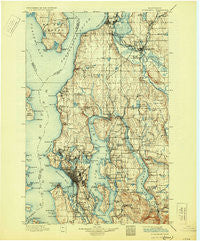
~ Snohomish WA topo map, 1:125000 scale, 30 X 30 Minute, Historical, 1897, updated 1930
Snohomish, Washington, USGS topographic map dated 1897.
Includes geographic coordinates (latitude and longitude). This topographic map is suitable for hiking, camping, and exploring, or framing it as a wall map.
Printed on-demand using high resolution imagery, on heavy weight and acid free paper, or alternatively on a variety of synthetic materials.
Topos available on paper, Waterproof, Poly, or Tyvek. Usually shipping rolled, unless combined with other folded maps in one order.
- Product Number: USGS-5411352
- Free digital map download (high-resolution, GeoPDF): Snohomish, Washington (file size: 10 MB)
- Map Size: please refer to the dimensions of the GeoPDF map above
- Weight (paper map): ca. 55 grams
- Map Type: POD USGS Topographic Map
- Map Series: HTMC
- Map Verison: Historical
- Cell ID: 66651
- Scan ID: 243815
- Imprint Year: 1930
- Survey Year: 1895
- Datum: Unstated
- Map Projection: Polyconic
- Map published by United States Geological Survey
- Map Language: English
- Scanner Resolution: 600 dpi
- Map Cell Name: Snohomish
- Grid size: 30 X 30 Minute
- Date on map: 1897
- Map Scale: 1:125000
- Geographical region: Washington, United States
Neighboring Maps:
All neighboring USGS topo maps are available for sale online at a variety of scales.
Spatial coverage:
Topo map Snohomish, Washington, covers the geographical area associated the following places:
- Trailer Lane Mobile Park - Cavalero Corner - Woodway - Wilburton - University - Lake Park - Wallingford - Paramount Park - Sand Point - Pines - Suburban Villa Mobile Home Park - Medina - Everett - Newport Shores - Pontiac - West Seattle - North Creek - Pinehurst - Mount View Villa Mobile Home Park - J and L Mobile Home Park - Kennard Corner - McGilvara - Shady Glen Mobile Home Park - Hawthorne Hills - University District - Finn Hill - Sunset Village - Mariner Village Mobile Home Park - Hilltop - Turner Corner - River Shores Mobile Home Park - Newport Hills - Columbia - King's Mobile Home Court - Mill Creek - Edmonds - Richmond Beach - Westburg Mobile Park - Lake Hills - Roxbury Heights - Bryn Mawr - Casino Corner - Montlake - Beardens Mobile Home Park - Lost Lake Mobile Home Park - Newport - Rainier Beach - Edgewater Park - Woodinville - Victory Heights - Canyon Recreational Vehicle Park - Coalfield - Meridian Village Mobile Home - Center Mobile Park - Maple Leaf - Meadowdale Mobile Home Park - Houghton - Kirkland - Greenwood - Feriton - Sarvis Mobile Estates - Valley View Mobile Manor - Mukilteo - Spring Beach - Denny Regrade - Duwamish - Laurelhurst - Echo Lake - Possession - Bitter Lake - Silver Shores Senior Mobile Home Park - North Creek Mobile Home Park - Vasa Park - Marks Mobile Home Park - Edgewater - Frontier Manor Mobile Home Park - Sammamish - Country Carriage Estates Mobile Home Park - Highlands - Beverly Acres - Redmond - Manor Heights Mobile Home Park - Overlake - Beacon Hill - North College Park - Martha Lake - West Lake Stevens - Oskams Corner - Clyde - Briarcrest - Campton - Crown Hill - Darlington - Lago de Plata Villa Mobile Home Park - Snohomish Mobile Home Park - Machias Mobile Manor - Midvale Corner - Fremont - Lake Terrace Court Mobile Home Park - The Highlands
- Map Area ID: AREA4847.5-122.5-122
- Northwest corner Lat/Long code: USGSNW48-122.5
- Northeast corner Lat/Long code: USGSNE48-122
- Southwest corner Lat/Long code: USGSSW47.5-122.5
- Southeast corner Lat/Long code: USGSSE47.5-122
- Northern map edge Latitude: 48
- Southern map edge Latitude: 47.5
- Western map edge Longitude: -122.5
- Eastern map edge Longitude: -122


