
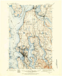
~ Snohomish WA topo map, 1:125000 scale, 30 X 30 Minute, Historical, 1895, updated 1954
Snohomish, Washington, USGS topographic map dated 1895.
Includes geographic coordinates (latitude and longitude). This topographic map is suitable for hiking, camping, and exploring, or framing it as a wall map.
Printed on-demand using high resolution imagery, on heavy weight and acid free paper, or alternatively on a variety of synthetic materials.
Topos available on paper, Waterproof, Poly, or Tyvek. Usually shipping rolled, unless combined with other folded maps in one order.
- Product Number: USGS-5411346
- Free digital map download (high-resolution, GeoPDF): Snohomish, Washington (file size: 10 MB)
- Map Size: please refer to the dimensions of the GeoPDF map above
- Weight (paper map): ca. 55 grams
- Map Type: POD USGS Topographic Map
- Map Series: HTMC
- Map Verison: Historical
- Cell ID: 66651
- Scan ID: 243811
- Imprint Year: 1954
- Survey Year: 1895
- Datum: Unstated
- Map Projection: Polyconic
- Map published by United States Geological Survey
- Map Language: English
- Scanner Resolution: 600 dpi
- Map Cell Name: Snohomish
- Grid size: 30 X 30 Minute
- Date on map: 1895
- Map Scale: 1:125000
- Geographical region: Washington, United States
Neighboring Maps:
All neighboring USGS topo maps are available for sale online at a variety of scales.
Spatial coverage:
Topo map Snohomish, Washington, covers the geographical area associated the following places:
- Magnolia Bluff - Clyde Hill - Wedgwood - The Highlands - May Creek - Edgewater Park - Freeway Place Mobile Home Park - Edgewater (historical) - Everett - Coal Creek - Columbia Beach - Courtyard Mobile Home Park - Newport - Chelsea - Firwood Lane Mobile Home Park - Fairway Estates Senior Mobile Home Park - Adelaide - Newcastle - Vasa Park - Intercity - Kenmore - Cathcart - Holly Park - Mariner Village Mobile Home Park - South Park - Bryn Mawr Properties Mobile Home Park - Spring Beach - Village Green Mobile Home Park - Robinswood - Georgetown - Northgate - Interbay - West Lake Sammamish - Hilltop - Lowell - North Creek Mobile Home Park - Montlake - Earlmont - Darlington - Briercrest - Lake Terrace Court Mobile Home Park - Beverly Acres - Hunts Point - Nelsons Corner - Country Club Senior Mobile Park - Royal Coachman Mobile Home Park - Westward Mobile Park - Tally Ho Mobile Home Park - Mount Baker - Sunset Hill - Alki - Echo Lake - Endolyne - Lost Lake Mobile Home Park - Cascade Vista Mobile Estates - Green Acres Mobile Home Park - North Broadway - Clearview - Clinton - Halo Mobile Home Park - Broadview - Inglewood - Willows - Silver Firs - Plantation Mobile Home Park - Lynnwood Mobile Park - North Beach - Mukilteo - Feriton - Penny Lynn Mobile Home Park - Yeomalt - Northrup - Brighton - Factoria - Moorlands - Martha Lake - Snyders Corner - Phinney Ridge - Ballard - Serene Terrace Mobile Home Park - Kenilworth - Newport Shores - Lockwood Village Mobile Home Park - University Village - Lakewood Villa Mobile Home Park - Carlton Park - Avondale - Fourth Avenue West Estates Mobile Home Park - Morningside - Seattle - Woodinville - Wayne - Crown Hill - Avon Villa Mobile Home Park - Haller Lake - Bothell - Pinehurst - Inglewood - Machias - Youngstown
- Map Area ID: AREA4847.5-122.5-122
- Northwest corner Lat/Long code: USGSNW48-122.5
- Northeast corner Lat/Long code: USGSNE48-122
- Southwest corner Lat/Long code: USGSSW47.5-122.5
- Southeast corner Lat/Long code: USGSSE47.5-122
- Northern map edge Latitude: 48
- Southern map edge Latitude: 47.5
- Western map edge Longitude: -122.5
- Eastern map edge Longitude: -122


