
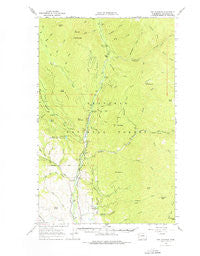
~ Doe Mountain WA topo map, 1:62500 scale, 15 X 15 Minute, Historical, 1963, updated 1976
Doe Mountain, Washington, USGS topographic map dated 1963.
Includes geographic coordinates (latitude and longitude). This topographic map is suitable for hiking, camping, and exploring, or framing it as a wall map.
Printed on-demand using high resolution imagery, on heavy weight and acid free paper, or alternatively on a variety of synthetic materials.
Topos available on paper, Waterproof, Poly, or Tyvek. Usually shipping rolled, unless combined with other folded maps in one order.
- Product Number: USGS-5409752
- Free digital map download (high-resolution, GeoPDF): Doe Mountain, Washington (file size: 8 MB)
- Map Size: please refer to the dimensions of the GeoPDF map above
- Weight (paper map): ca. 55 grams
- Map Type: POD USGS Topographic Map
- Map Series: HTMC
- Map Verison: Historical
- Cell ID: 53484
- Scan ID: 240869
- Imprint Year: 1976
- Woodland Tint: Yes
- Aerial Photo Year: 1957
- Field Check Year: 1963
- Datum: NAD27
- Map Projection: Polyconic
- Map published by United States Geological Survey
- Map Language: English
- Scanner Resolution: 600 dpi
- Map Cell Name: Doe Mountain
- Grid size: 15 X 15 Minute
- Date on map: 1963
- Map Scale: 1:62500
- Geographical region: Washington, United States
Neighboring Maps:
All neighboring USGS topo maps are available for sale online at a variety of scales.
Spatial coverage:
Topo map Doe Mountain, Washington, covers the geographical area associated the following places:
- Methow Valley Community School - Eightmile Ridge - Sherwood Creek - Sullivan Pond - Baldy Creek - Eightmile Creek - North Fork Twentymile Trail - Nice Campground - Valley Creek - North Fork Twentymile Trail - South Twentymile Trail - Alex Creek - Second Creek - Doe Creek - Twentymile Trail - Bromas Creek - Eightmile Ranch - Wright Ponds-West Pond Dam - Claw Creek - Pete Creek - Ramsey Peak - Cub Creek - Camp Four Campground - Buck Lake Campground - Lamb Butte - Doe Mountain - Pebble Creek - Memorial Campground - Falls Creek - Wright Ponds-East Pond - July Creek - Fly Creek - Boulder Creek - First Creek - Ramsey Creek - Spur Peak - Brevicomis Creek - First Butte - Pearrygin Trail - Meadow Lake - Eightmile - Falls Creek Falls - Siegels Slough - Lamb Creek - North Fork Boulder Creek - South Twentymile Peak - Little Cub Creek - South Fork Boulder Creek - Paul Mountain - Wright Ponds-West Pond - Wright Ponds-East Pond Dam - Pearrygin Peak - Buck Creek - Junior Creek - Leroy Creek - Boulder Creek - Flat Campground - Ike Mountain - Deer Creek - Spring Creek - Butte Creek - Buck Lake - Honeymoon Creek - Third Creek - Falls Creek Campground - Chewuch Campground - Middle Fork Boulder Creek - Yarrow Creek - Buck Mountain - Timber Creek - Bud Creek - Ortell Creek - Dodd Creek - Tripod Peak - Okanogan National Forest - Lewis Butte - No Snake Creek - Farewell Peak - Twentymile Creek
- Map Area ID: AREA48.7548.5-120.25-120
- Northwest corner Lat/Long code: USGSNW48.75-120.25
- Northeast corner Lat/Long code: USGSNE48.75-120
- Southwest corner Lat/Long code: USGSSW48.5-120.25
- Southeast corner Lat/Long code: USGSSE48.5-120
- Northern map edge Latitude: 48.75
- Southern map edge Latitude: 48.5
- Western map edge Longitude: -120.25
- Eastern map edge Longitude: -120


