
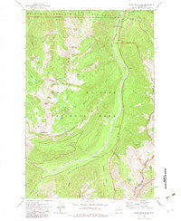
~ White River Park WA topo map, 1:24000 scale, 7.5 X 7.5 Minute, Historical, 1971, updated 1983
White River Park, Washington, USGS topographic map dated 1971.
Includes geographic coordinates (latitude and longitude). This topographic map is suitable for hiking, camping, and exploring, or framing it as a wall map.
Printed on-demand using high resolution imagery, on heavy weight and acid free paper, or alternatively on a variety of synthetic materials.
Topos available on paper, Waterproof, Poly, or Tyvek. Usually shipping rolled, unless combined with other folded maps in one order.
- Product Number: USGS-5409222
- Free digital map download (high-resolution, GeoPDF): White River Park, Washington (file size: 16 MB)
- Map Size: please refer to the dimensions of the GeoPDF map above
- Weight (paper map): ca. 55 grams
- Map Type: POD USGS Topographic Map
- Map Series: HTMC
- Map Verison: Historical
- Cell ID: 48747
- Scan ID: 244662
- Imprint Year: 1983
- Woodland Tint: Yes
- Aerial Photo Year: 1970
- Field Check Year: 1971
- Datum: NAD27
- Map Projection: Lambert Conformal Conic
- Map published by United States Geological Survey
- Map Language: English
- Scanner Resolution: 600 dpi
- Map Cell Name: White River Park
- Grid size: 7.5 X 7.5 Minute
- Date on map: 1971
- Map Scale: 1:24000
- Geographical region: Washington, United States
Neighboring Maps:
All neighboring USGS topo maps are available for sale online at a variety of scales.
Spatial coverage:
Topo map White River Park, Washington, covers the geographical area associated the following places:
- Parkway - Deadwood Creek - Silver Creek Guard Station - Green Park - Dege Peak - Silver Springs - Sourdough Gap - Wright Creek - Governors Ridge - Shaw Creek - Bear Park - Goat Creek - Sunrise Ridge - Marcus Peak - White River Ranger Station - Slide Mountain - Fawn Ridge - The Palisades - White River Park - Silver Creek - Lower Crystal Lake - Sunrise Creek - Klickitat Creek - Brown Peak - Crystal Lake - Bear Lake - Deadwood Lakes - Crystal Creek - Fryingpan Creek - Lower Palisades Lake - Crystal Mountain - Sourdough Mountains - Clover Lake - Burnt Park - Sunrise Lake - Upper Palisades Lake - Silver Springs Campground - Hidden Lake - Sunrise Point - Sheep Lake
- Map Area ID: AREA4746.875-121.625-121.5
- Northwest corner Lat/Long code: USGSNW47-121.625
- Northeast corner Lat/Long code: USGSNE47-121.5
- Southwest corner Lat/Long code: USGSSW46.875-121.625
- Southeast corner Lat/Long code: USGSSE46.875-121.5
- Northern map edge Latitude: 47
- Southern map edge Latitude: 46.875
- Western map edge Longitude: -121.625
- Eastern map edge Longitude: -121.5


