
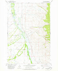
~ Fox Gulch MT topo map, 1:24000 scale, 7.5 X 7.5 Minute, Historical, 1978, updated 1979
Fox Gulch, Montana, USGS topographic map dated 1978.
Includes geographic coordinates (latitude and longitude). This topographic map is suitable for hiking, camping, and exploring, or framing it as a wall map.
Printed on-demand using high resolution imagery, on heavy weight and acid free paper, or alternatively on a variety of synthetic materials.
Topos available on paper, Waterproof, Poly, or Tyvek. Usually shipping rolled, unless combined with other folded maps in one order.
- Product Number: USGS-5393934
- Free digital map download (high-resolution, GeoPDF): Fox Gulch, Montana (file size: 10 MB)
- Map Size: please refer to the dimensions of the GeoPDF map above
- Weight (paper map): ca. 55 grams
- Map Type: POD USGS Topographic Map
- Map Series: HTMC
- Map Verison: Historical
- Cell ID: 16185
- Scan ID: 263900
- Imprint Year: 1979
- Woodland Tint: Yes
- Aerial Photo Year: 1967
- Edit Year: 1978
- Field Check Year: 1974
- Datum: NAD27
- Map Projection: Polyconic
- Map published by United States Geological Survey
- Map Language: English
- Scanner Resolution: 600 dpi
- Map Cell Name: Fox Gulch
- Grid size: 7.5 X 7.5 Minute
- Date on map: 1978
- Map Scale: 1:24000
- Geographical region: Montana, United States
Neighboring Maps:
All neighboring USGS topo maps are available for sale online at a variety of scales.
Spatial coverage:
Topo map Fox Gulch, Montana, covers the geographical area associated the following places:
- Jardine Ditch Number One - Warm Springs Creek - Miner Creek - Willow Ranch - 04S15W29ADDC01 Well - Forty Bar Ranch - Cox Ranch - Broomfield Gulch - Helming Ditch - Helming Ditch - Fox School (historical) - 05S15W19DBAC01 Well - Huntley Ditch - South Branch Miner Creek - Miller Ditch - 04S15W20BDCB01 Well - Big Ditch - Cow Cabin Creek - Popularis Cemetery - Hirschy Landing Strip (historical) - South Branch Big Swamp Creek - Hirschy Ranch - 04S15W20CBAA01 Well - 04S15W29ADCA01 Well - Little Lake Creek - North Branch Miner Creek - 05S15W10AADB01 Well - Fox Post Office (historical) - 05S15W03BDBC01 Well - 04S15W29ADDB01 Well - Fox Gulch - 04S15W28BDDC01 Well - Spring (historical) - 05S15W10DCDD01 Well - Ice Pond - North Branch Big Swamp Creek - 04S15W29ADCA02 Well - 05S15W17BABA01 Well
- Map Area ID: AREA45.545.375-113.5-113.375
- Northwest corner Lat/Long code: USGSNW45.5-113.5
- Northeast corner Lat/Long code: USGSNE45.5-113.375
- Southwest corner Lat/Long code: USGSSW45.375-113.5
- Southeast corner Lat/Long code: USGSSE45.375-113.375
- Northern map edge Latitude: 45.5
- Southern map edge Latitude: 45.375
- Western map edge Longitude: -113.5
- Eastern map edge Longitude: -113.375


