
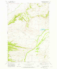
~ Cinnamon Spring MT topo map, 1:24000 scale, 7.5 X 7.5 Minute, Historical, 1972, updated 1976
Cinnamon Spring, Montana, USGS topographic map dated 1972.
Includes geographic coordinates (latitude and longitude). This topographic map is suitable for hiking, camping, and exploring, or framing it as a wall map.
Printed on-demand using high resolution imagery, on heavy weight and acid free paper, or alternatively on a variety of synthetic materials.
Topos available on paper, Waterproof, Poly, or Tyvek. Usually shipping rolled, unless combined with other folded maps in one order.
- Product Number: USGS-5392382
- Free digital map download (high-resolution, GeoPDF): Cinnamon Spring, Montana (file size: 10 MB)
- Map Size: please refer to the dimensions of the GeoPDF map above
- Weight (paper map): ca. 55 grams
- Map Type: POD USGS Topographic Map
- Map Series: HTMC
- Map Verison: Historical
- Cell ID: 8783
- Scan ID: 262999
- Imprint Year: 1976
- Woodland Tint: Yes
- Aerial Photo Year: 1971
- Field Check Year: 1972
- Datum: NAD27
- Map Projection: Lambert Conformal Conic
- Map published by United States Geological Survey
- Map Language: English
- Scanner Resolution: 600 dpi
- Map Cell Name: Cinnamon Spring
- Grid size: 7.5 X 7.5 Minute
- Date on map: 1972
- Map Scale: 1:24000
- Geographical region: Montana, United States
Neighboring Maps:
All neighboring USGS topo maps are available for sale online at a variety of scales.
Spatial coverage:
Topo map Cinnamon Spring, Montana, covers the geographical area associated the following places:
- Top Hat Ranch - McFarland-White Ranch - Big Elk Dam - Buzzard Creek - Martin and C Bar J Reservoir - Spring Creek - Coffin Butte - Willow Creek - Jack Arthur Ridge - Cinnamon Spring - Cinnamon Creek - Station Creek - 06N13E05C___01 Well - White Elk Dam
- Map Area ID: AREA46.37546.25-110.25-110.125
- Northwest corner Lat/Long code: USGSNW46.375-110.25
- Northeast corner Lat/Long code: USGSNE46.375-110.125
- Southwest corner Lat/Long code: USGSSW46.25-110.25
- Southeast corner Lat/Long code: USGSSE46.25-110.125
- Northern map edge Latitude: 46.375
- Southern map edge Latitude: 46.25
- Western map edge Longitude: -110.25
- Eastern map edge Longitude: -110.125


