
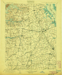
~ Dover DE topo map, 1:125000 scale, 30 X 30 Minute, Historical, 1906
Dover, Delaware, USGS topographic map dated 1906.
Includes geographic coordinates (latitude and longitude). This topographic map is suitable for hiking, camping, and exploring, or framing it as a wall map.
Printed on-demand using high resolution imagery, on heavy weight and acid free paper, or alternatively on a variety of synthetic materials.
Topos available on paper, Waterproof, Poly, or Tyvek. Usually shipping rolled, unless combined with other folded maps in one order.
- Product Number: USGS-5390388
- Free digital map download (high-resolution, GeoPDF): Dover, Delaware (file size: 8 MB)
- Map Size: please refer to the dimensions of the GeoPDF map above
- Weight (paper map): ca. 55 grams
- Map Type: POD USGS Topographic Map
- Map Series: HTMC
- Map Verison: Historical
- Cell ID: 65368
- Scan ID: 255750
- Survey Year: 1896
- Datum: Unstated
- Map Projection: Unstated
- Map published by United States Geological Survey
- Map Language: English
- Scanner Resolution: 600 dpi
- Map Cell Name: Dover
- Grid size: 30 X 30 Minute
- Date on map: 1906
- Map Scale: 1:125000
- Geographical region: Delaware, United States
Neighboring Maps:
All neighboring USGS topo maps are available for sale online at a variety of scales.
Spatial coverage:
Topo map Dover, Delaware, covers the geographical area associated the following places:
- Deans Meadows - Greylag - Planters Woods - Cayots - Delaney Corner - Markeys Mobile Home Park - Springview - Lakewind - Thomas Landing - Mount Zion - Strimels Mobile Home Park - Newmans Corner - Fredericktown - Casson Corner - Garrison Lake Green - El Dondo Acres - Rodney Village - Oak Point Acres - Normansmeade - Melville Crossroads - Bork Acres - Edgehill Acres - Dexter Corners - Great Oak Farms - Presidential Courts - Baltimore Corner - Ben Lee Estates - Saint Augustine - Canterbury - Hedgerow Hollow Mobile Home Park - The Plains - Huntley Circle - Sagefield - Pheasantfield - Olivet Hill - Carlisle Village - Weidman - Forrest Grove Village Mobile Home Park - Lords Corner - Paden Corner - The Island - The Orchard - Lynn Woods - Browns Corner - Duck Creek Landing - Voshell Cove - Unicorn - Gregg Neck - Char-Nor Manor - Southwood Acres Mobile Home Park - Lakewind III - Maplehurst - Sabarto East - Warrens Mobile Home Park - Wynn Wood - Honeysuckle Knoll - Union Corner - Woods Manor - Lone Star Mobile Home Park - Sherwood - Fairfield Farms - Choptank Pines - Brick Store - Blackbird - Indian Acres - Sudlersville - Golts - Meadow Vista - Bombay Woods - Earleville - McGinnes - Deep Branch Farm - Harrison Knoll - Cleavers Corner - Village of Westover - Mayfair - Oaknoll - Brookfield - Glencoe - Ridgewood Manor - Heatherfield - Eagles Nest - Barclay Farms - Hickory Dale Acres - Unicorn Crossing - Green Spring Farm - Forest Landing - Lyn Woods - Richardson Estates - Pheasant Point II - Georgetown - Harmony Corner - Royal Grant - Rolling Meadows - Hunters Point - Windy Way - Felton Manor - Star Hill Village - Morris Estates - Cassidy Wharf
- Map Area ID: AREA39.539-76-75.5
- Northwest corner Lat/Long code: USGSNW39.5-76
- Northeast corner Lat/Long code: USGSNE39.5-75.5
- Southwest corner Lat/Long code: USGSSW39-76
- Southeast corner Lat/Long code: USGSSE39-75.5
- Northern map edge Latitude: 39.5
- Southern map edge Latitude: 39
- Western map edge Longitude: -76
- Eastern map edge Longitude: -75.5


