
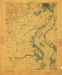
~ Wilmington DE topo map, 1:62500 scale, 15 X 15 Minute, Historical, 1906, updated 1910
Wilmington, Delaware, USGS topographic map dated 1906.
Includes geographic coordinates (latitude and longitude). This topographic map is suitable for hiking, camping, and exploring, or framing it as a wall map.
Printed on-demand using high resolution imagery, on heavy weight and acid free paper, or alternatively on a variety of synthetic materials.
Topos available on paper, Waterproof, Poly, or Tyvek. Usually shipping rolled, unless combined with other folded maps in one order.
- Product Number: USGS-5390368
- Free digital map download (high-resolution, GeoPDF): Wilmington, Delaware (file size: 9 MB)
- Map Size: please refer to the dimensions of the GeoPDF map above
- Weight (paper map): ca. 55 grams
- Map Type: POD USGS Topographic Map
- Map Series: HTMC
- Map Verison: Historical
- Cell ID: 64586
- Scan ID: 255799
- Imprint Year: 1910
- Datum: Unstated
- Map Projection: Unstated
- Map published by United States Geological Survey
- Map Language: English
- Scanner Resolution: 600 dpi
- Map Cell Name: Wilmington
- Grid size: 15 X 15 Minute
- Date on map: 1906
- Map Scale: 1:62500
- Geographical region: Delaware, United States
Neighboring Maps:
All neighboring USGS topo maps are available for sale online at a variety of scales.
Spatial coverage:
Topo map Wilmington, Delaware, covers the geographical area associated the following places:
- New Castle - Pleasant Hill - Duross Heights - Wellington Woods - Coach Hill - Liberty - South Wilmington - Lauren Farms - Caravel Farms - Saint Georges - Fern Hook - Harmony - Tybouts Corner - Belltown Woods - Colonial Heights - Fredericks Addition - Brookbend - Deacons Walk - Little Jersey - Shingle Landing - Stony Crest - Ogletown - Linden Square - Christiana Village - Oakmont - Plum Run - The Village of Drummond Hill - Pendrew Manor - Silverbrook Gardens - Boxwood - Brookside - Washington Park - Reybold - Roselle Terrace - Montclare - Newark - Forest Park - Woodcrest - Wilmington Manor Gardens - Yorkshire - The Highlands - Latimer Estates - Stones Throw - Pencader Village - Hickory Woods - Meadowbrook Farms South - Chapel Hill - Delaware City - Kiamensi - Washington Heights - Basin Corner - Saint Georges Heights - Weatherhill Farms - Swanwyck Estates - Rosegate - Birds Corner - Heritage - Rogers Corners - Biddles Corner - Stanton - Richardson Park - Fairway Falls - Dragon Run Terrace Mobile Home Park - Woodside Manor - Countryside Farms - Cedars Knoll - Hayden Park - Overview Gardens - Belvidere - Parkwood - Sheffield Manor - Corner Ketch - Marydale - Scarborough Park - Woodland Park - Farnhurst - Jamestowne - Heritage Farms - Four Seasons Park - Eden Park Gardens - Windy Hills - Keeney - Milltown - Pine Swamp Corner - Minquadale Trailer Village - Kirkwood - Fairwinds - Beaver Brook Apartments - Millside - Moores Acres - Churchtown - Heather Woods - Timber Ridge - Varlano - Beechers Lot - Glen Berne Estates - Brookmont Farms - Hyde Park - Leedon Estates - Sycamore Gardens
- Map Area ID: AREA39.7539.5-75.75-75.5
- Northwest corner Lat/Long code: USGSNW39.75-75.75
- Northeast corner Lat/Long code: USGSNE39.75-75.5
- Southwest corner Lat/Long code: USGSSW39.5-75.75
- Southeast corner Lat/Long code: USGSSE39.5-75.5
- Northern map edge Latitude: 39.75
- Southern map edge Latitude: 39.5
- Western map edge Longitude: -75.75
- Eastern map edge Longitude: -75.5


