
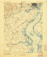
~ Wilmington DE topo map, 1:62500 scale, 15 X 15 Minute, Historical, 1906
Wilmington, Delaware, USGS topographic map dated 1906.
Includes geographic coordinates (latitude and longitude). This topographic map is suitable for hiking, camping, and exploring, or framing it as a wall map.
Printed on-demand using high resolution imagery, on heavy weight and acid free paper, or alternatively on a variety of synthetic materials.
Topos available on paper, Waterproof, Poly, or Tyvek. Usually shipping rolled, unless combined with other folded maps in one order.
- Product Number: USGS-5390366
- Free digital map download (high-resolution, GeoPDF): Wilmington, Delaware (file size: 8 MB)
- Map Size: please refer to the dimensions of the GeoPDF map above
- Weight (paper map): ca. 55 grams
- Map Type: POD USGS Topographic Map
- Map Series: HTMC
- Map Verison: Historical
- Cell ID: 64586
- Scan ID: 255798
- Datum: Unstated
- Map Projection: Unstated
- Map published by United States Geological Survey
- Map Language: English
- Scanner Resolution: 600 dpi
- Map Cell Name: Wilmington
- Grid size: 15 X 15 Minute
- Date on map: 1906
- Map Scale: 1:62500
- Geographical region: Delaware, United States
Neighboring Maps:
All neighboring USGS topo maps are available for sale online at a variety of scales.
Spatial coverage:
Topo map Wilmington, Delaware, covers the geographical area associated the following places:
- Christiana Green - Colony Hills - Christiana Village - Leedon Estates - Simonds Gardens - Eastburn Heights - Manor Park Apartments - Melody Meadows II - Heritage Farms - Kings Croft - Gams Crest - Milford Meadows - Millside - Manette Heights - Cedar Heights - Piermont Woods - Lindell Square - Brookside - Shingle Landing - Corbit - Lindell Village - Milltown - Oakwood Beach - Prices Corner - Dunleith - Rutherford - Cavaliers Country Club Apartments - Elmhurst - Cedars - Coach Hill - Old Mill Manor - Porter Square - Stones Throw - Shenandoah - Todd Estates - Pinecrest - Silverbrook Gardens - Saint Georges Heights - Breezewood II - Arbor Pointe Apartments - Christiana Acres - English Village - Landenberg Junction - Sycamore Gardens - Cranston Heights - Pine Swamp Corner - Duncan Woods - Pike Creek - Skyline Crest - Meadowood - The Villa - West Meadow - Brookhaven - Boyds Corner - South Wilmington - Hickory Woods - Ashley Heights - Roselle Terrace - Woodcrest - Greenbridge - Dragon Run Terrace Mobile Home Park - Mermaid Run - Oak Hollow - Fort Elfsborg - Landlith - Timber Ridge - Dunlinden Acres - Colonial Village Apartments - Pencader - Rolling Hills - Scarborough Park - Rogers Corners - Mayview Manor - Corner Ketch - The Woods - Delaplane Manor - Wood Wards Addition - Swanwyck - Greenbridge - Brandywine Springs - Christiana Landing - Robscott Manor - Deacons Walk - Newark Oaks - Drummond Ridge - Delpark Manor - The Cedars - Fairway Falls - Lakecroft II - Brookland Terrace - Pendrew Manor - Woodside Manor - Four Seasons Park - The Bluffs - Newport Heights - Biddles Corner - Marabou Meadows - Crystal Run Farm - Cooper Farm - Fox Chase Park
- Map Area ID: AREA39.7539.5-75.75-75.5
- Northwest corner Lat/Long code: USGSNW39.75-75.75
- Northeast corner Lat/Long code: USGSNE39.75-75.5
- Southwest corner Lat/Long code: USGSSW39.5-75.75
- Southeast corner Lat/Long code: USGSSE39.5-75.5
- Northern map edge Latitude: 39.75
- Southern map edge Latitude: 39.5
- Western map edge Longitude: -75.75
- Eastern map edge Longitude: -75.5


