
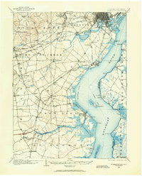
~ Wilmington DE topo map, 1:62500 scale, 15 X 15 Minute, Historical, 1904, updated 1961
Wilmington, Delaware, USGS topographic map dated 1904.
Includes geographic coordinates (latitude and longitude). This topographic map is suitable for hiking, camping, and exploring, or framing it as a wall map.
Printed on-demand using high resolution imagery, on heavy weight and acid free paper, or alternatively on a variety of synthetic materials.
Topos available on paper, Waterproof, Poly, or Tyvek. Usually shipping rolled, unless combined with other folded maps in one order.
- Product Number: USGS-5390364
- Free digital map download (high-resolution, GeoPDF): Wilmington, Delaware (file size: 8 MB)
- Map Size: please refer to the dimensions of the GeoPDF map above
- Weight (paper map): ca. 55 grams
- Map Type: POD USGS Topographic Map
- Map Series: HTMC
- Map Verison: Historical
- Cell ID: 64586
- Scan ID: 255796
- Imprint Year: 1961
- Survey Year: 1904
- Datum: NAD27
- Map Projection: Polyconic
- Map published by United States Geological Survey
- Map Language: English
- Scanner Resolution: 600 dpi
- Map Cell Name: Wilmington
- Grid size: 15 X 15 Minute
- Date on map: 1904
- Map Scale: 1:62500
- Geographical region: Delaware, United States
Neighboring Maps:
All neighboring USGS topo maps are available for sale online at a variety of scales.
Spatial coverage:
Topo map Wilmington, Delaware, covers the geographical area associated the following places:
- Heritage - Parkside - Linden Green Apartment - Marydale - Melody Meadows II - Wellington Woods - Newark - Boxwood - Fort Elfsborg - Airmont Acres - Mount Pleasant Mobile Home Park - Newark Oaks - Deacons Walk - Hyde Park - Shenandoah - Stones Throw - Lauren Farms - Cedar Heights - Greenbridge - Pendrew Manor - Redmont - Washington Park - Keystone - Landers Park - Colony Hills - Jamestowne - Little Jersey - Birds Corner - Albion - Mahoneyville - Piermont Woods - Salem Village - The Hills of Skyline - Oakwood Beach - Milford Crossroads - Garwood Estates - Duross Heights - Capital Trail Farms - Hayden Park - Kirkwood Gardens - Bestfield - Choate - Lancaster Village - Marshallton - Stratford - Rutherford - Scottfield - Woodshade - Village of Cantebury - Millside - Kirkwood - The Elms - Prices Corner - Wood Wards Addition - Chapel Hill - Victoria Woods - Pigeon Run - Forest Brook Glen - Catalina Gardens - Champlin Village - Keeney - Greenleaf Manor - Gordy Estates - Iron Hills Apartments - Oakdale - Penn Acres - Bear - Limestone Gap - Drummond Ridge - Woodcreek - Countryside Farms - Delpark Manor - Glenville - Pepper Ridge - Marabou Meadows - Eastburn Farms - Sycamore Gardens - Saint Georges - Cooper Farm - Penns Beach - Lakecroft II - Penn Acres South - Fairwinds Mobile Home Park - Ivy Ridge - Belltown Woods - Rambleton Acres - Cedar Farms - Salem Woods - Centennial Village - Fox Woods - Delaplane Manor - Scarborough Park - Monterey Farms - Swanwyck Gardens - Wood Mill - Edgebrooke - Liberty - Four Seasons Park - The Cedars - Roseville Park
- Map Area ID: AREA39.7539.5-75.75-75.5
- Northwest corner Lat/Long code: USGSNW39.75-75.75
- Northeast corner Lat/Long code: USGSNE39.75-75.5
- Southwest corner Lat/Long code: USGSSW39.5-75.75
- Southeast corner Lat/Long code: USGSSE39.5-75.5
- Northern map edge Latitude: 39.75
- Southern map edge Latitude: 39.5
- Western map edge Longitude: -75.75
- Eastern map edge Longitude: -75.5


