
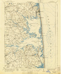
~ Rehoboth DE topo map, 1:62500 scale, 15 X 15 Minute, Historical, 1918, updated 1940
Rehoboth, Delaware, USGS topographic map dated 1918.
Includes geographic coordinates (latitude and longitude). This topographic map is suitable for hiking, camping, and exploring, or framing it as a wall map.
Printed on-demand using high resolution imagery, on heavy weight and acid free paper, or alternatively on a variety of synthetic materials.
Topos available on paper, Waterproof, Poly, or Tyvek. Usually shipping rolled, unless combined with other folded maps in one order.
- Product Number: USGS-5390348
- Free digital map download (high-resolution, GeoPDF): Rehoboth, Delaware (file size: 6 MB)
- Map Size: please refer to the dimensions of the GeoPDF map above
- Weight (paper map): ca. 55 grams
- Map Type: POD USGS Topographic Map
- Map Series: HTMC
- Map Verison: Historical
- Cell ID: 61545
- Scan ID: 255777
- Imprint Year: 1940
- Edit Year: 1938
- Survey Year: 1917
- Datum: NAD
- Map Projection: Polyconic
- Map published by United States Geological Survey
- Map published by United States Army Corps of Engineers
- Map published by United States Department of War
- Map Language: English
- Scanner Resolution: 600 dpi
- Map Cell Name: Rehoboth
- Grid size: 15 X 15 Minute
- Date on map: 1918
- Map Scale: 1:62500
- Geographical region: Delaware, United States
Neighboring Maps:
All neighboring USGS topo maps are available for sale online at a variety of scales.
Spatial coverage:
Topo map Rehoboth, Delaware, covers the geographical area associated the following places:
- River Village Mobile Home Park - Old Landing Woods - Angola by the Bay - Shockley Heights - Red Mill Farms - Blackwater - South Bethany - Indian River Acres - Banks Harbor Estates - Holly Forest - Nassau Park Mobile Home Park - Ocean Village - Banks Development - West Rehoboth - Beaver Dam Acres - Warwick - Truitts Midway Development - Danfield Acres - Hidden Acres - Sloan Landing - Silver Lake Shores - Indiantown Farms - Clarksville - Cuelen Acres - Fox Hollow - Captains Grant Mobile Home Park - Collins Creek Estates - Hollyville Acres - Bay Harbor - Rehoboth Shores Mobile Home Park - Bullseye - Driftwood Village Mobile Home Park - Foxfire Meadow - Pot Nets West - Bank Harbor Retreat - Lochwood - Tru Vale Acres - North Shores - William Ritter Manor - The Glade - West Bay Park Mobile Home Park - Log Cabin Mobile Home Park - Henlopen Acres - Piney Glade - Dodds Addition - Buck Hill Landing - Belltown - Camelot Mobile Home Park - Cedar Shores - Lazy Lagoon Mobile Home Park - Enchanted Acres Mobile Home Park - Sea Farers Village - Bottom Hills - Lingo Estate Mobile Home Park - Angola Crest II Mobile Home Park - Nanticoke Shores Mobile Home Park - Mallard Point - Blackwater Village - Long Acres - Dogwood Acres Mobile Home Park - Ben Robins Landing - Bayberry Dunes - John Marsh Landing - Murrays Haven - Omar - Fox Run Mobile Home Park - Massey Landing - Beachfield - Gulls Nest - Fairmount - Midway Estates - Bay View Park - Woods Edge - Three Seasons Mobile Home Park - Pine Valley Mobile Home Park - Tuckahoe Acres - Silver View Farm - Sea Colony East - Indian Landing Mobile Home Park - Greens Landing - Banks Acres - Millville - Carpenters Corner - Pinetown - Washington Heights - Webb Landing - Old Landing - Collins Park Mobile Home Park - Midway Park Subdivision - Herring Landing - Shady Grove - Pine Manor Estates - Sandy Landing - Pinepoint Mobile Home Park - Sherwood Acres - Trinity - Meyle Estates - Denton Mills - Pond Acres - Sandy Brae
- Map Area ID: AREA38.7538.5-75.25-75
- Northwest corner Lat/Long code: USGSNW38.75-75.25
- Northeast corner Lat/Long code: USGSNE38.75-75
- Southwest corner Lat/Long code: USGSSW38.5-75.25
- Southeast corner Lat/Long code: USGSSE38.5-75
- Northern map edge Latitude: 38.75
- Southern map edge Latitude: 38.5
- Western map edge Longitude: -75.25
- Eastern map edge Longitude: -75


