
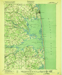
~ Rehoboth DE topo map, 1:62500 scale, 15 X 15 Minute, Historical, 1918
Rehoboth, Delaware, USGS topographic map dated 1918.
Includes geographic coordinates (latitude and longitude). This topographic map is suitable for hiking, camping, and exploring, or framing it as a wall map.
Printed on-demand using high resolution imagery, on heavy weight and acid free paper, or alternatively on a variety of synthetic materials.
Topos available on paper, Waterproof, Poly, or Tyvek. Usually shipping rolled, unless combined with other folded maps in one order.
- Product Number: USGS-5390340
- Free digital map download (high-resolution, GeoPDF): Rehoboth, Delaware (file size: 7 MB)
- Map Size: please refer to the dimensions of the GeoPDF map above
- Weight (paper map): ca. 55 grams
- Map Type: POD USGS Topographic Map
- Map Series: HTMC
- Map Verison: Historical
- Cell ID: 61545
- Scan ID: 255773
- Woodland Tint: Yes
- Visual Version Number: 2
- Survey Year: 1917
- Datum: Unstated
- Map Projection: Unstated
- Map published by United States Geological Survey
- Map published by United States Army Corps of Engineers
- Map published by United States Department of War
- Map Language: English
- Scanner Resolution: 600 dpi
- Map Cell Name: Rehoboth
- Grid size: 15 X 15 Minute
- Date on map: 1918
- Map Scale: 1:62500
- Geographical region: Delaware, United States
Neighboring Maps:
All neighboring USGS topo maps are available for sale online at a variety of scales.
Spatial coverage:
Topo map Rehoboth, Delaware, covers the geographical area associated the following places:
- Indian Harbor Villa - Herring Landing - Greens Landing - Murry Landing - Colonial East Mobile Home Park - Bay Colony - Indian Landing Mobile Home Park - Tuckahoe Acres - Ocean View - The Plantations - Orchard Manor - Israel Haul - Hollymount - Indian Beach - Herring Creek Estates - The Landing - Warwick Park - Old Landing - Cozy Cove Mobile Home Park - Dagsboro - Angola Crest II Mobile Home Park - Indian River Acres - Miller Creek Park Mobile Home Park - Rehoboth Shores Mobile Home Park - Sea Colony - Sea Farers Village - Hollyville Acres - Steele Acres - Bethany Dunes - Long Neck Village Mobile Home Park - Shell Landing - Holiday Pines - Belltown - Rogers Haven - Piney Glade - Midway Park - Edgewood Manor - Sheep Pen Landing - Lingo Landing - Oak Meadows Mobile Home Park - Shady Ridge - Mill Run Acres - Fairmount - Club House Landing - Meyle Estates - West Bay Park Mobile Home Park - Carpenters Corner - Buck Hill Landing - Shawns Hideaway Mobile Home Park - Sea Del Estates - Tru Vale Acres - Ocean Village - Piney Point - Shady Grove - White House Beach Mobile Home Park - Shockley Heights - Hollyville - Lazy Lagoon Mobile Home Park - Country Estates - Gull Point - Banks Acres - Angola Beach Mobile Home Park - Collins Creek Estates - Cuelen Acres - Millville - Fishermans Park Mobile Home Park - Bottom Hills - Pots Nets North Mobile Home Park - Long Acres - Byewood Manor - Sherwood Acres - Indiantown Farms - Midway Park Subdivision - Conley Chapel Village Mobile Home Park - Ocean Way Estates - Foxfire Meadow - Prince George Acres - Cool Spring Farms Mobile Home Park - Breezewood - Banks Development - Fairway Villas - Frankford - Country Village - Silver Lake Manor - Camelot Mobile Home Park - Bay City Mobile Home Park - Omar - Pinepoint Mobile Home Park - Plantation Park II Mobile Home Park - Rehoboth Beach - Shady Dell Mobile Home Park - Massey Landing - Fisher Landing - Pinetown - Banksville Park - Clarksville - Newtons Acres - Tower Shores - The Landing - John Marsh Landing
- Map Area ID: AREA38.7538.5-75.25-75
- Northwest corner Lat/Long code: USGSNW38.75-75.25
- Northeast corner Lat/Long code: USGSNE38.75-75
- Southwest corner Lat/Long code: USGSSW38.5-75.25
- Southeast corner Lat/Long code: USGSSE38.5-75
- Northern map edge Latitude: 38.75
- Southern map edge Latitude: 38.5
- Western map edge Longitude: -75.25
- Eastern map edge Longitude: -75


