
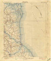
~ Bowers DE topo map, 1:62500 scale, 15 X 15 Minute, Historical, 1936
Bowers, Delaware, USGS topographic map dated 1936.
Includes geographic coordinates (latitude and longitude). This topographic map is suitable for hiking, camping, and exploring, or framing it as a wall map.
Printed on-demand using high resolution imagery, on heavy weight and acid free paper, or alternatively on a variety of synthetic materials.
Topos available on paper, Waterproof, Poly, or Tyvek. Usually shipping rolled, unless combined with other folded maps in one order.
- Product Number: USGS-5390294
- Free digital map download (high-resolution, GeoPDF): Bowers, Delaware (file size: 7 MB)
- Map Size: please refer to the dimensions of the GeoPDF map above
- Weight (paper map): ca. 55 grams
- Map Type: POD USGS Topographic Map
- Map Series: HTMC
- Map Verison: Historical
- Cell ID: 51683
- Scan ID: 255728
- Survey Year: 1934
- Datum: NAD
- Map Projection: Polyconic
- Map published by United States Geological Survey
- Map Language: English
- Scanner Resolution: 600 dpi
- Map Cell Name: Bowers
- Grid size: 15 X 15 Minute
- Date on map: 1936
- Map Scale: 1:62500
- Geographical region: Delaware, United States
Neighboring Maps:
All neighboring USGS topo maps are available for sale online at a variety of scales.
Spatial coverage:
Topo map Bowers, Delaware, covers the geographical area associated the following places:
- Frenchs Mobile Homes - Webb Landing - Laffertys Corner - Little Creek - Doverbrook Gardens - Bayview Heights - Grandview Meadows - Wickham Woods - South Bowers - Brookhaven Estates - Kings Cliff Mobile Home Park - Silver Maple Mobile Home Park - Little Heaven - Barkers Landing Estates - Donas Landing - Hunters Ridge - Frederica - Bowers Beach - High Point Mobile Home Park - Kitts Hummock - Shadybrook Farms - Locustville - Generals Green - Barkers Landing - Postles Corner - George Meyers Development - Cypress Gardens - Hilldale - Florence - Bay View Heights - Oak Grove - Church Creek - Cowgills Corner - Magnolia Mobile Home Park - Warren Landing - Hideaway Acres - Little Creek Landing - Port Mahon - Otters Run - Oak Shadows - Dover East Estates Mobile Home Park - Magnolia - Bowers Landing - Brookdale Heights - White House Landing - Generals Greene - Eagle Heights - Misty Pines
- Map Area ID: AREA39.2539-75.5-75.25
- Northwest corner Lat/Long code: USGSNW39.25-75.5
- Northeast corner Lat/Long code: USGSNE39.25-75.25
- Southwest corner Lat/Long code: USGSSW39-75.5
- Southeast corner Lat/Long code: USGSSE39-75.25
- Northern map edge Latitude: 39.25
- Southern map edge Latitude: 39
- Western map edge Longitude: -75.5
- Eastern map edge Longitude: -75.25


