
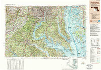
~ Washington DC topo map, 1:250000 scale, 1 X 2 Degree, Historical, 1989, updated 1989
Washington, District of Columbia, USGS topographic map dated 1989.
Includes geographic coordinates (latitude and longitude). This topographic map is suitable for hiking, camping, and exploring, or framing it as a wall map.
Printed on-demand using high resolution imagery, on heavy weight and acid free paper, or alternatively on a variety of synthetic materials.
Topos available on paper, Waterproof, Poly, or Tyvek. Usually shipping rolled, unless combined with other folded maps in one order.
- Product Number: USGS-5389860
- Free digital map download (high-resolution, GeoPDF): Washington, District of Columbia (file size: 31 MB)
- Map Size: please refer to the dimensions of the GeoPDF map above
- Weight (paper map): ca. 55 grams
- Map Type: POD USGS Topographic Map
- Map Series: HTMC
- Map Verison: Historical
- Cell ID: 69087
- Scan ID: 255916
- Imprint Year: 1989
- Woodland Tint: Yes
- Edit Year: 1989
- Datum: NAD27
- Map Projection: Universal Transverse Mercator
- Map published by United States Geological Survey
- Map Language: English
- Scanner Resolution: 600 dpi
- Map Cell Name: Washington
- Grid size: 1 X 2 Degree
- Date on map: 1989
- Map Scale: 1:250000
- Geographical region: District of Columbia, United States
Neighboring Maps:
All neighboring USGS topo maps are available for sale online at a variety of scales.
Spatial coverage:
Topo map Washington, District of Columbia, covers the geographical area associated the following places:
- Bull Run Mobile Home Park - Chapel Oaks - Tranquility - Lindau Woods - Westview Hills - Burnt Mill - Ritchie - Burning Oaks - Westphalia - Highland Park - Massaponax - West Springfield - Royal Oak - Breezy Knoll Estates - Burgundy Village - Wrights - Heatherwick - Scotland Beach - Saint Leonard Shores - Towlston Meadow - Beverly Beach - Oak Estates - Saint Margarets Grove - Singerly - Allencrest - Newtown - Bexley Manor - Crosswinds - Glendale Heights - Musgrove Estates - Driftwood Beach - Port Tobacco Lakes - Cheverly - King George Estates - Currioman Landing - Beverly Estates - Quiet Acres - Forest Park - Ilda - Wilton Woods - Stoke - Plum Tree - Friendship Village - Holly Hill - North Bend Woodland - Broyhill-McLean Estates - Brentwood Estates - River Heights - Bledsoe Corner - Cedarville - Kenmore - Holly Corners - Greenwood Manor - New Market - Lindendale - Tilghman Island Beach - Bannockburn Estates - A Country Place - Red Hill - Chevy Chase Village - Fort Washington - Gum Swamp - Annapolis Landing - Bayside - Ravensworth - Long Branch - Meadowville - Romancoke - Colonial Village - Sales Corner - Cropley - Drumcliff - Bertha - Rogers Mill - Discovery - Five Forks - Greens Rest Manor - Cornwell - Bladensburg - Hunt Valley Estates - Forest Heights - Shea Estates - Rolling Hills - Cedarhurst - Lakewood Estates - Huntley Estates - Friendship Heights - Oaklands - Morgansburg - Collingwood - Cedar Knolls Estates - Lahore - Bristol - South River Spring Lakes - Chestnut Hill - Colonial Acres - Huckleberry Woods - Potomac Heights - Green Acres Estates - Chevalle
- Map Area ID: AREA3938-78-76
- Northwest corner Lat/Long code: USGSNW39-78
- Northeast corner Lat/Long code: USGSNE39-76
- Southwest corner Lat/Long code: USGSSW38-78
- Southeast corner Lat/Long code: USGSSE38-76
- Northern map edge Latitude: 39
- Southern map edge Latitude: 38
- Western map edge Longitude: -78
- Eastern map edge Longitude: -76


