
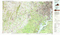
~ Washington West DC topo map, 1:100000 scale, 30 X 60 Minute, Historical, 1982, updated 1983
Washington West, District of Columbia, USGS topographic map dated 1982.
Includes geographic coordinates (latitude and longitude). This topographic map is suitable for hiking, camping, and exploring, or framing it as a wall map.
Printed on-demand using high resolution imagery, on heavy weight and acid free paper, or alternatively on a variety of synthetic materials.
Topos available on paper, Waterproof, Poly, or Tyvek. Usually shipping rolled, unless combined with other folded maps in one order.
- Product Number: USGS-5389858
- Free digital map download (high-resolution, GeoPDF): Washington West, District of Columbia (file size: 37 MB)
- Map Size: please refer to the dimensions of the GeoPDF map above
- Weight (paper map): ca. 55 grams
- Map Type: POD USGS Topographic Map
- Map Series: HTMC
- Map Verison: Historical
- Cell ID: 76846
- Scan ID: 257715
- Imprint Year: 1983
- Woodland Tint: Yes
- Aerial Photo Year: 1980
- Edit Year: 1982
- Datum: NAD27
- Map Projection: Universal Transverse Mercator
- Map published by United States Geological Survey
- Map Language: English
- Scanner Resolution: 600 dpi
- Map Cell Name: Washington West
- Grid size: 30 X 60 Minute
- Date on map: 1982
- Map Scale: 1:100000
- Geographical region: District of Columbia, United States
Neighboring Maps:
All neighboring USGS topo maps are available for sale online at a variety of scales.
Spatial coverage:
Topo map Washington West, District of Columbia, covers the geographical area associated the following places:
- Frogtown - Browns Mill - Woodburn - Tohoga (historical) - Conklin - Westminster - Country Club Hills - South Riding - Belleview - Malbrook - Franklin Forest - Franconia - Foster Fork - Colonial Village - Barksdale - Rosedale Park - Arna Valley - Mount Vernon - Magee - York manor - Franklin Park - Emery Corners - Bryan Point - Lousetown - Bristow - Vannoy Park - Newton Woods - Virginia Forest - Arlingwood - Bushy Acres - Columbia Park - Tantallon - Fort Washington - Kerfoot - The Cloisters - Zouave Hills - Sligo - Rosslyn - Kenwood - Morgantown - Princedale - Warren Woods - Ilda - North Potomac Vista - Cobbs Corner - Garden City - Cookes Park - Walters Woods - Kenwood - Pisgah - Hillbrook - Bellevue Forest - Swansen - Columbia Forest - Park Place - Fairview Heights (historical) - Chapel Hill - Odricks Corner - Chevy Chase Heights - College Park - Brightwood - Yorkshire Village - The Palisades - Arlington - Bristersburg - Arlington Heights - Country Club Manor - Green Meadows - Chesterbrook - Lincoln Park - Tyler Gardens - Sunny Bank (historical) - Sideburn - Country Club Grove - Alwington - Cardinal Heights - Smallwood Estates - Brookfield - English Village - Bleak - Westchester - Terrapin Forest - Holly Acres Mobile Home Park - Beverly Forest - Friendship Heights - Centreville Farms - Quantico - Mountainview - Graystone Estates - Redhill Estates - Chevy Chase Village - Eustaces Corner - Orlean - Saint Stephens - Woodmont - Mill Creek Park - Sunnybrook Estates - Ridgedale - Shepherd Park - Westgate
- Map Area ID: AREA3938.5-78-77
- Northwest corner Lat/Long code: USGSNW39-78
- Northeast corner Lat/Long code: USGSNE39-77
- Southwest corner Lat/Long code: USGSSW38.5-78
- Southeast corner Lat/Long code: USGSSE38.5-77
- Northern map edge Latitude: 39
- Southern map edge Latitude: 38.5
- Western map edge Longitude: -78
- Eastern map edge Longitude: -77


