
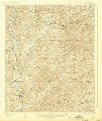
~ Sharon SC topo map, 1:62500 scale, 15 X 15 Minute, Historical, 1907, updated 1942
Sharon, South Carolina, USGS topographic map dated 1907.
Includes geographic coordinates (latitude and longitude). This topographic map is suitable for hiking, camping, and exploring, or framing it as a wall map.
Printed on-demand using high resolution imagery, on heavy weight and acid free paper, or alternatively on a variety of synthetic materials.
Topos available on paper, Waterproof, Poly, or Tyvek. Usually shipping rolled, unless combined with other folded maps in one order.
- Product Number: USGS-5388938
- Free digital map download (high-resolution, GeoPDF): Sharon, South Carolina (file size: 11 MB)
- Map Size: please refer to the dimensions of the GeoPDF map above
- Weight (paper map): ca. 55 grams
- Map Type: POD USGS Topographic Map
- Map Series: HTMC
- Map Verison: Historical
- Cell ID: 62402
- Scan ID: 261937
- Imprint Year: 1942
- Survey Year: 1905
- Datum: Unstated
- Map Projection: Polyconic
- Map published by United States Geological Survey
- Map Language: English
- Scanner Resolution: 600 dpi
- Map Cell Name: Sharon
- Grid size: 15 X 15 Minute
- Date on map: 1907
- Map Scale: 1:62500
- Geographical region: South Carolina, United States
Neighboring Maps:
All neighboring USGS topo maps are available for sale online at a variety of scales.
Spatial coverage:
Topo map Sharon, South Carolina, covers the geographical area associated the following places:
- Blairsville - Calvin (historical) - No Mans Land (historical) - Red Hill - Bullock Creek - Hickory Grove - Abingdon - Armenia - Hoodtown - Cotton (historical) - Etta (historical) - Cabal - Borax (historical) - Sutton Spring (historical) - Lockhart - Smith Ford - Sharon - Hopewell - Pinckney - Clarkson (historical) - Beauty Spot (historical) - Pinckneyville - Gould (historical)
- Map Area ID: AREA3534.75-81.5-81.25
- Northwest corner Lat/Long code: USGSNW35-81.5
- Northeast corner Lat/Long code: USGSNE35-81.25
- Southwest corner Lat/Long code: USGSSW34.75-81.5
- Southeast corner Lat/Long code: USGSSE34.75-81.25
- Northern map edge Latitude: 35
- Southern map edge Latitude: 34.75
- Western map edge Longitude: -81.5
- Eastern map edge Longitude: -81.25


