
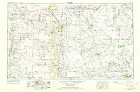
~ Hobbs NM topo map, 1:250000 scale, 1 X 2 Degree, Historical, 1954, updated 1963
Hobbs, New Mexico, USGS topographic map dated 1954.
Includes geographic coordinates (latitude and longitude). This topographic map is suitable for hiking, camping, and exploring, or framing it as a wall map.
Printed on-demand using high resolution imagery, on heavy weight and acid free paper, or alternatively on a variety of synthetic materials.
Topos available on paper, Waterproof, Poly, or Tyvek. Usually shipping rolled, unless combined with other folded maps in one order.
- Product Number: USGS-5386470
- Free digital map download (high-resolution, GeoPDF): Hobbs, New Mexico (file size: 13 MB)
- Map Size: please refer to the dimensions of the GeoPDF map above
- Weight (paper map): ca. 55 grams
- Map Type: POD USGS Topographic Map
- Map Series: HTMC
- Map Verison: Historical
- Cell ID: 68824
- Scan ID: 190935
- Imprint Year: 1963
- Woodland Tint: Yes
- Photo Revision Year: 1962
- Aerial Photo Year: 1954
- Edit Year: 1962
- Field Check Year: 1954
- Datum: Unstated
- Map Projection: Transverse Mercator
- Map published by United States Geological Survey
- Map Language: English
- Scanner Resolution: 600 dpi
- Map Cell Name: Hobbs
- Grid size: 1 X 2 Degree
- Date on map: 1954
- Map Scale: 1:250000
- Geographical region: New Mexico, United States
Neighboring Maps:
All neighboring USGS topo maps are available for sale online at a variety of scales.
Spatial coverage:
Topo map Hobbs, New Mexico, covers the geographical area associated the following places:
- Maljamar - Seagraves - Baird Place - Halfway - Monument - Jones City - Ross Place - Shafter Lake (historical) - Eunice - Punkin Center - Patricia - Florey - White City - Medlin Place - Air Base City - Ashmore - Warren - Sixteen Corner Windmill - Waldon Place Windmill - Maypens - Frankel City - Adair - Gardendale - McKinney Acres - Union - Allred - Pierce Canyon Crossing - Welch - Oil Center - Paynes Corner - Friendship - Knowles - Scharbauer City - Loop - Andrews - Sand - Loco Hills - North Cowden - Andrews Place - Denver City - Lea - Fairview - Bennett - Hobbs - Jal - Cotton Place - Buckeye - State Line - Humble City - Lovington - Mungerville - Coyote Corner - Ochoa - Arkansas Junction - Nadine - Old Place Windmills - Pride - Chub - Higginbotham - Seminole
- Map Area ID: AREA3332-104-102
- Northwest corner Lat/Long code: USGSNW33-104
- Northeast corner Lat/Long code: USGSNE33-102
- Southwest corner Lat/Long code: USGSSW32-104
- Southeast corner Lat/Long code: USGSSE32-102
- Northern map edge Latitude: 33
- Southern map edge Latitude: 32
- Western map edge Longitude: -104
- Eastern map edge Longitude: -102


