
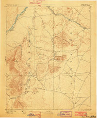
~ San Pedro NM topo map, 1:125000 scale, 30 X 30 Minute, Historical, 1892, updated 1902
San Pedro, New Mexico, USGS topographic map dated 1892.
Includes geographic coordinates (latitude and longitude). This topographic map is suitable for hiking, camping, and exploring, or framing it as a wall map.
Printed on-demand using high resolution imagery, on heavy weight and acid free paper, or alternatively on a variety of synthetic materials.
Topos available on paper, Waterproof, Poly, or Tyvek. Usually shipping rolled, unless combined with other folded maps in one order.
- Product Number: USGS-5386348
- Free digital map download (high-resolution, GeoPDF): San Pedro, New Mexico (file size: 7 MB)
- Map Size: please refer to the dimensions of the GeoPDF map above
- Weight (paper map): ca. 55 grams
- Map Type: POD USGS Topographic Map
- Map Series: HTMC
- Map Verison: Historical
- Cell ID: 66550
- Scan ID: 189415
- Imprint Year: 1902
- Survey Year: 1889
- Datum: Unstated
- Map Projection: Unstated
- Map published by United States Geological Survey
- Map Language: English
- Scanner Resolution: 600 dpi
- Map Cell Name: San Pedro
- Grid size: 30 X 30 Minute
- Date on map: 1892
- Map Scale: 1:125000
- Geographical region: New Mexico, United States
Neighboring Maps:
All neighboring USGS topo maps are available for sale online at a variety of scales.
Spatial coverage:
Topo map San Pedro, New Mexico, covers the geographical area associated the following places:
- Tejon (historical) - Coyote (historical) - Martin Place - Cedar Crest - Cerrillos - Cedro - Kemp (historical) - Frost (historical) - San Antonio - Madrid - San Pedro Creek - Village de las Huertas - Forest Park - Johns Place - Rosario - Cañoncito - Tierra Monte Subdivision - Las Colonias - Horton Place - La Madera - Las Huertas - Placitas - Gallegos - Tijeras - Sedillo - Canyon Estates - Paako Communities - El Refugio - The Overlook - Sandia Knolls - Corners - Barton - Monticello - Los Pinos - Hyer - San Felipe Pueblo - Blackwell Place - Dolores (historical) - Tecolote - Hagan (historical) - Algodones - Puertecito - Agua (historical) - Waldo (historical) - Edgewood - Puesta Del Sol - Montezuma (historical) - Los Cerrilos - Cedar Grove - Placitas Homesteads - Dennison Place - Rincon - San Antonito - Sandia Park - Ranchos des Placitas - Diamond Tail Ranch - P Simmons Place - Dennis Chaves Estates - Casa Loma - Angostura - Jarett Place - Briggs Place - Otto - Tinen Place - Carnuel - San Pedro Overlook - Pinon Ridge Estates - Primera Agua - San Pedro - Ortiz (historical) - Los Pastores - Vista de Oro de Placitas - Sandia Heights - Cavasos Place - Golden - Sierra Vista Estates - Juan Tomas - El Tablazon - Zamora - Sundance Mesa - Magic Valley - Evergreen Hills Subdivision
- Map Area ID: AREA35.535-106.5-106
- Northwest corner Lat/Long code: USGSNW35.5-106.5
- Northeast corner Lat/Long code: USGSNE35.5-106
- Southwest corner Lat/Long code: USGSSW35-106.5
- Southeast corner Lat/Long code: USGSSE35-106
- Northern map edge Latitude: 35.5
- Southern map edge Latitude: 35
- Western map edge Longitude: -106.5
- Eastern map edge Longitude: -106


