
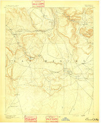
~ Bernal NM topo map, 1:125000 scale, 30 X 30 Minute, Historical, 1891
Bernal, New Mexico, USGS topographic map dated 1891.
Includes geographic coordinates (latitude and longitude). This topographic map is suitable for hiking, camping, and exploring, or framing it as a wall map.
Printed on-demand using high resolution imagery, on heavy weight and acid free paper, or alternatively on a variety of synthetic materials.
Topos available on paper, Waterproof, Poly, or Tyvek. Usually shipping rolled, unless combined with other folded maps in one order.
- Product Number: USGS-5386224
- Free digital map download (high-resolution, GeoPDF): Bernal, New Mexico (file size: 6 MB)
- Map Size: please refer to the dimensions of the GeoPDF map above
- Weight (paper map): ca. 55 grams
- Map Type: POD USGS Topographic Map
- Map Series: HTMC
- Map Verison: Historical
- Cell ID: 64986
- Scan ID: 189282
- Survey Year: 1890
- Datum: Unstated
- Map Projection: Unstated
- Map published by United States Geological Survey
- Map Language: English
- Scanner Resolution: 600 dpi
- Map Cell Name: Bernal
- Grid size: 30 X 30 Minute
- Date on map: 1891
- Map Scale: 1:125000
- Geographical region: New Mexico, United States
Neighboring Maps:
All neighboring USGS topo maps are available for sale online at a variety of scales.
Spatial coverage:
Topo map Bernal, New Mexico, covers the geographical area associated the following places:
- San Jose - Tecolote - Serafina - Gonzales Ranch - Ojita - Chapelle - Llano Viejo - Coruco - Lovato - Lagunita - La Fragua - Santa Ana - Los Montoyas - Upper Anton Chico - Llano Del Medio - San Juan - Bernal - Upper Pueblo - Gabaldon - Lower Pueblo - Lucero - San Augustin - El Ancon - El Cerrito - Soham - Blanchard - Sena - Upper Dilia - La Liendre - Dilia - Garanbuio - Sands - Cedar Hill - Myers - Villanueva - Aurora - Sheridan - Pinos Altos - Dahlia - Barranco - Anton Chico - Apache Springs - Tecolotito - Ribera - Cedar Hill - San Miguel
- Map Area ID: AREA35.535-105.5-105
- Northwest corner Lat/Long code: USGSNW35.5-105.5
- Northeast corner Lat/Long code: USGSNE35.5-105
- Southwest corner Lat/Long code: USGSSW35-105.5
- Southeast corner Lat/Long code: USGSSE35-105
- Northern map edge Latitude: 35.5
- Southern map edge Latitude: 35
- Western map edge Longitude: -105.5
- Eastern map edge Longitude: -105


