
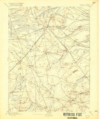
~ Whiting NJ topo map, 1:62500 scale, 15 X 15 Minute, Historical, 1888, updated 1916
Whiting, New Jersey, USGS topographic map dated 1888.
Includes geographic coordinates (latitude and longitude). This topographic map is suitable for hiking, camping, and exploring, or framing it as a wall map.
Printed on-demand using high resolution imagery, on heavy weight and acid free paper, or alternatively on a variety of synthetic materials.
Topos available on paper, Waterproof, Poly, or Tyvek. Usually shipping rolled, unless combined with other folded maps in one order.
- Product Number: USGS-5377592
- Free digital map download (high-resolution, GeoPDF): Whiting, New Jersey (file size: 7 MB)
- Map Size: please refer to the dimensions of the GeoPDF map above
- Weight (paper map): ca. 55 grams
- Map Type: POD USGS Topographic Map
- Map Series: HTMC
- Map Verison: Historical
- Cell ID: 64506
- Scan ID: 255414
- Imprint Year: 1916
- Survey Year: 1884
- Datum: Unstated
- Map Projection: Unstated
- Map published by United States Geological Survey
- Map Language: English
- Scanner Resolution: 600 dpi
- Map Cell Name: Whiting
- Grid size: 15 X 15 Minute
- Date on map: 1888
- Map Scale: 1:62500
- Geographical region: New Jersey, United States
Neighboring Maps:
All neighboring USGS topo maps are available for sale online at a variety of scales.
Spatial coverage:
Topo map Whiting, New Jersey, covers the geographical area associated the following places:
- Crestwood Village - Brighton at Barnegat Mobile Home Park - Cedar Glen Lakes - Davenport (historical) - Pine Ridge at Crestwood - Holiday Heights - Camp Columbus - Wheatland - Wrangell Brook Park - Buckingham - Howardsville - Woodmansie - Aserdaten (historical) - Dover Forge - Keswick Grove - Cedar Crest - Crossley (historical) - Red Oak Grove - Roosevelt City - Pinewood Estates Mobile Home Park - Bamber Lake - Brookville - Barnegat Estates - Whiting - Wells Mills - Bullock - Lacey
- Map Area ID: AREA4039.75-74.5-74.25
- Northwest corner Lat/Long code: USGSNW40-74.5
- Northeast corner Lat/Long code: USGSNE40-74.25
- Southwest corner Lat/Long code: USGSSW39.75-74.5
- Southeast corner Lat/Long code: USGSSE39.75-74.25
- Northern map edge Latitude: 40
- Southern map edge Latitude: 39.75
- Western map edge Longitude: -74.5
- Eastern map edge Longitude: -74.25


