
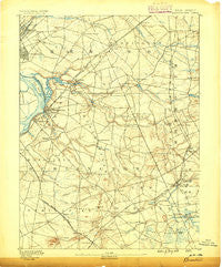
~ Bordentown NJ topo map, 1:62500 scale, 15 X 15 Minute, Historical, 1888
Bordentown, New Jersey, USGS topographic map dated 1888.
Includes geographic coordinates (latitude and longitude). This topographic map is suitable for hiking, camping, and exploring, or framing it as a wall map.
Printed on-demand using high resolution imagery, on heavy weight and acid free paper, or alternatively on a variety of synthetic materials.
Topos available on paper, Waterproof, Poly, or Tyvek. Usually shipping rolled, unless combined with other folded maps in one order.
- Product Number: USGS-5377092
- Free digital map download (high-resolution, GeoPDF): Bordentown, New Jersey (file size: 8 MB)
- Map Size: please refer to the dimensions of the GeoPDF map above
- Weight (paper map): ca. 55 grams
- Map Type: POD USGS Topographic Map
- Map Series: HTMC
- Map Verison: Historical
- Cell ID: 51649
- Scan ID: 255121
- Survey Year: 1885
- Datum: Unstated
- Map Projection: Unstated
- Map published by United States Geological Survey
- Map Language: English
- Scanner Resolution: 600 dpi
- Map Cell Name: Bordentown
- Grid size: 15 X 15 Minute
- Date on map: 1888
- Map Scale: 1:62500
- Geographical region: New Jersey, United States
Neighboring Maps:
All neighboring USGS topo maps are available for sale online at a variety of scales.
Spatial coverage:
Topo map Bordentown, New Jersey, covers the geographical area associated the following places:
- Wrightsville - Hornerstown - Pine Lane - Georgetown - White Horse - Chewalla Park - Extonville - Hutchinson Mills - Hockamik - Dunns Mills - Tilghmans Corner - Parsonville - Pages Corner - Hillside Terrace - Briar Manor - Ellisdale - Groveville - Pullentown - Brindletown - Sylvan Glen - Harneys Corner - Nottingham - Spring Mill - Arneytown - Pointville - Allentown - New Canton - Walnford - New Egypt - Trenton - Mansfield - Yardville Heights - Nelsonville - The Orchards - Golden Crest - Imlaystown - Bordentown - Trenton Gardens - Yardville - Bossert Estates - Chesterfield - Rosemont - Wrightstown - Cream Ridge - Windsor - New Sharon - Warner Village - Sykesville - Mercerville - Cookstown - Hedding - Lakeside Park - Polhemustown - Arneys Mount - Jacobstown - Hamilton Square - Eilers Corner - Robbinsville - Folwell - Homes Mills - Cooleys Corner - Lewistown - Davisville - Fort Dix - Creston - Mansfield Square - Sharon - Columbus - Fieldsboro - Mile Hollow - Crosswicks - Chambers Corners - Shrewsbury - Haines Corner - Meadows Terrace - Springfield - Kirbys Mills - Carsons Mills - Wallace Mill - Juliustown - Jobstown - North Crosswicks - Edgebrook - Sharp
- Map Area ID: AREA40.2540-74.75-74.5
- Northwest corner Lat/Long code: USGSNW40.25-74.75
- Northeast corner Lat/Long code: USGSNE40.25-74.5
- Southwest corner Lat/Long code: USGSSW40-74.75
- Southeast corner Lat/Long code: USGSSE40-74.5
- Northern map edge Latitude: 40.25
- Southern map edge Latitude: 40
- Western map edge Longitude: -74.75
- Eastern map edge Longitude: -74.5


