
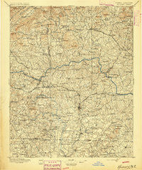
~ Hickory NC topo map, 1:125000 scale, 30 X 30 Minute, Historical, 1895
Hickory, North Carolina, USGS topographic map dated 1895.
Includes geographic coordinates (latitude and longitude). This topographic map is suitable for hiking, camping, and exploring, or framing it as a wall map.
Printed on-demand using high resolution imagery, on heavy weight and acid free paper, or alternatively on a variety of synthetic materials.
Topos available on paper, Waterproof, Poly, or Tyvek. Usually shipping rolled, unless combined with other folded maps in one order.
- Product Number: USGS-5374940
- Free digital map download (high-resolution, GeoPDF): Hickory, North Carolina (file size: 11 MB)
- Map Size: please refer to the dimensions of the GeoPDF map above
- Weight (paper map): ca. 55 grams
- Map Type: POD USGS Topographic Map
- Map Series: HTMC
- Map Verison: Historical
- Cell ID: 65674
- Scan ID: 161766
- Survey Year: 1894
- Datum: Unstated
- Map Projection: Unstated
- Map published by United States Geological Survey
- Map Language: English
- Scanner Resolution: 600 dpi
- Map Cell Name: Hickory
- Grid size: 30 X 30 Minute
- Date on map: 1895
- Map Scale: 1:125000
- Geographical region: North Carolina, United States
Neighboring Maps:
All neighboring USGS topo maps are available for sale online at a variety of scales.
Spatial coverage:
Topo map Hickory, North Carolina, covers the geographical area associated the following places:
- Berkshire Hills - North Hickory - Liledoun - Cedar Valley - Taylorsville - Downsville (historical) - Rhoney - Henry - Moores (historical) - Catfish - Old Farm - Petra Mills - Plateau - Dudley Shoals - Oxford Park - Newton - Mountain View Development - Maiden - Draco - Laurel Hollow - Seagles Store (historical) - Henry River - Northlakes - Cat Square - Banoak - Rocky Springs - Denver - Cedar Rock - Grace Chapel - Pumpkin Center - Hiddenite - North Lakes - Rhodhiss - Viewmont - Buffalo - Sweetwater - Hatterbrond (historical) - Mountain View - Drums Crossroads - Millersville - Cooksville - Advent Crossroads - Auld Farm - Vale - Little River - Providence Mill - Emanuel (historical) - Hulls Crossroads - Hudson - Isenhour Park - Oak Hill - Hickory - Claremont - Mayfield - Olivers Crossroads - Daniels - Penelope - Fairgrove - Maple Valley - Startown - Brookford - Sunrise Beach - Ellendale - Sardis (historical) - Bethlehem - Hildebran - Cedar Rock Estates - Concord (historical) - Scotts - Bandy - Fairview Park - Catawba - Fairbrook - Meadow Brook Village - Conover - Sharon - Baird (historical) - Murrays Hill - Mount Herman - Taylorsville Beach - LeMar Park - Longview - Duan - Saint Stephens - Granite Falls - Pleasant (historical) - Reepsville - Pinewood - Stony Point - New Hope (historical) - Witherspoon Crossroad - Midway - Icard - Sawmills - Bradford Crossroads - Vashti - Killian Crossroads - Brevard (historical) - Blackburn - Propst Crossroads
- Map Area ID: AREA3635.5-81.5-81
- Northwest corner Lat/Long code: USGSNW36-81.5
- Northeast corner Lat/Long code: USGSNE36-81
- Southwest corner Lat/Long code: USGSSW35.5-81.5
- Southeast corner Lat/Long code: USGSSE35.5-81
- Northern map edge Latitude: 36
- Southern map edge Latitude: 35.5
- Western map edge Longitude: -81.5
- Eastern map edge Longitude: -81


