
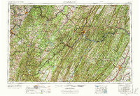
~ Cumberland MD topo map, 1:250000 scale, 1 X 2 Degree, Historical, 1956, updated 1972
Cumberland, Maryland, USGS topographic map dated 1956.
Includes geographic coordinates (latitude and longitude). This topographic map is suitable for hiking, camping, and exploring, or framing it as a wall map.
Printed on-demand using high resolution imagery, on heavy weight and acid free paper, or alternatively on a variety of synthetic materials.
Topos available on paper, Waterproof, Poly, or Tyvek. Usually shipping rolled, unless combined with other folded maps in one order.
- Product Number: USGS-5368746
- Free digital map download (high-resolution, GeoPDF): Cumberland, Maryland (file size: 30 MB)
- Map Size: please refer to the dimensions of the GeoPDF map above
- Weight (paper map): ca. 55 grams
- Map Type: POD USGS Topographic Map
- Map Series: HTMC
- Map Verison: Historical
- Cell ID: 68734
- Scan ID: 257775
- Imprint Year: 1972
- Woodland Tint: Yes
- Visual Version Number: 1
- Aerial Photo Year: 1952
- Edit Year: 1969
- Field Check Year: 1956
- Datum: Unstated
- Map Projection: Transverse Mercator
- Map published by United States Geological Survey
- Map Language: English
- Scanner Resolution: 600 dpi
- Map Cell Name: Cumberland
- Grid size: 1 X 2 Degree
- Date on map: 1956
- Map Scale: 1:250000
- Geographical region: Maryland, United States
Neighboring Maps:
All neighboring USGS topo maps are available for sale online at a variety of scales.
Spatial coverage:
Topo map Cumberland, Maryland, covers the geographical area associated the following places:
- Lardin - Lowndes - Rodemer - Canterburg - McCoole - Sprucetown - Juniata - Kirt - Hopewell - Wildwood Hills - Lahmansville - Freyco - Koontz - Isabella - Fairfax - Reeses Mill - Woodland - Canyon - Laurel Falls - Slabtown - Bidwell - Bevansville - Gibbon Glade - Millertown - Rocks Works - Laurel Run - Farmington - Dayton - Corinth - Pleasant Grove - Elk Branch (historical) - Northwood Hills - Town Hill - Carlos - Smock - Lonaconing - Riverside - Tulip - Seymourville - Unamis - Ohiopyle - Spohrs Crossroads - Mineral Spring - Sabraton - Ravenwood Estates - Gannon - Caddell - Location - Piedmont - Evitts Creek - Cedar Cliff - Gladesville - Wagoner - Eckhart Junction - Flat Rock - Mountain Falls - Floyd - Baker Ridge - Mount Storm - Victoria - Ott Town - Blue Hill - Rolling Fields - Claude - High View - Shanty Town (historical) - Knobmount - Bertha Hill - Morgantown - Gravel Pit - Dott - Kearney - Moffitt Sterling - High View Manor - Cunningham - Ridgeville - Indian Creek - Ridgedale - Stonerville - Hobson (historical) - Rock Forge - Harmony Grove - Martin - Jimtown - Dugan Hill - Reliance - Glade City - Whetsell (historical) - Eckhart Mines - Allegany Grove - Lashley - Champwood - Hutchinson - Little Summit - Barrelville - Buffington - Mountain Lake Park - Horse Shoe Run - Mann - Canaan Heights
- Map Area ID: AREA4039-80-78
- Northwest corner Lat/Long code: USGSNW40-80
- Northeast corner Lat/Long code: USGSNE40-78
- Southwest corner Lat/Long code: USGSSW39-80
- Southeast corner Lat/Long code: USGSSE39-78
- Northern map edge Latitude: 40
- Southern map edge Latitude: 39
- Western map edge Longitude: -80
- Eastern map edge Longitude: -78


