
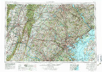
~ Baltimore MD topo map, 1:250000 scale, 1 X 2 Degree, Historical, 1957, updated 1979
Baltimore, Maryland, USGS topographic map dated 1957.
Includes geographic coordinates (latitude and longitude). This topographic map is suitable for hiking, camping, and exploring, or framing it as a wall map.
Printed on-demand using high resolution imagery, on heavy weight and acid free paper, or alternatively on a variety of synthetic materials.
Topos available on paper, Waterproof, Poly, or Tyvek. Usually shipping rolled, unless combined with other folded maps in one order.
- Product Number: USGS-5368734
- Free digital map download (high-resolution, GeoPDF): Baltimore, Maryland (file size: 30 MB)
- Map Size: please refer to the dimensions of the GeoPDF map above
- Weight (paper map): ca. 55 grams
- Map Type: POD USGS Topographic Map
- Map Series: HTMC
- Map Verison: Historical
- Cell ID: 74996
- Scan ID: 257768
- Imprint Year: 1979
- Woodland Tint: Yes
- Visual Version Number: 1
- Aerial Photo Year: 1976
- Edit Year: 1978
- Field Check Year: 1957
- Datum: Unstated
- Map Projection: Transverse Mercator
- Map published by United States Geological Survey
- Map Language: English
- Scanner Resolution: 600 dpi
- Map Cell Name: Baltimore
- Grid size: 1 X 2 Degree
- Date on map: 1957
- Map Scale: 1:250000
- Geographical region: Maryland, United States
Neighboring Maps:
All neighboring USGS topo maps are available for sale online at a variety of scales.
Spatial coverage:
Topo map Baltimore, Maryland, covers the geographical area associated the following places:
- Fox Den Farms - Grange - Geraghty Village - Zeman - Clarks Gap - Center Mills - Ten Hills - Orchards of Linthicum - Patapsco Park - Pleasant Valley - Palisades on the Severn - Fairfield - Midway Pines - Valley View - Merriweather - Norbeck - Howard Hills - Rattle Ridge - Wakefield Mill - Garretts Mill - Reeses Corner - Mill Green - Bartville - Brightwood Terrace - Oldfield - Piney Creek (historical) - Provinces - Pleasant Acres - Crest Valley - Briar Lea - Kesselring - Wrightsdale - Reynolds Mill - Ralston - Hipsleys Mill - Highfields - Potomac Farms - Valley Vista North - Woods Edge - Winterborn - Corsica Landing Estates - Blenheim - Magothy Beach - New Design Acres - Brown Heights - Dickeyville - Bowlder - Summerhill - Seven Oaks - Windsong Farms - Maryland Beach - Myers Estates - Laurel Acres - Heritage Woods - Cherry Hill - Ashley Mobile Home Park - Milburn on the Magothy - Cashtown - Hillbrook - Northbrook Estates - Armistead Homes - Hillandale Trailer Park - Brightwater Beach - Aspen Knolls - Hanesville - Smeltzer - Washington Manor Park - Ivory Mill - Charlesville - Water Oak Cove - Urbana - Glenbauer - Snyders Landing - Churchville - Lutes - Darryl Gardens - Strathcona Hills - Woodward - New Park - Kent Acres - Glenridge Estates - Harbour Oaks - Sleepy Hollow Mobile Home Park - Van Dyke Manor - Hunters Run - The Pines - Winter Springs - Honeysuckle Hollow - O'Donnell - Horman - Whitehall Beach - Marys Choice - Bridgeville - Edgewood Heights - Lafayettes Crossing - Wakely Terrace - Stonehaven - Wolfs Mill - Canbury Woods - Merridale
- Map Area ID: AREA4039-78-76
- Northwest corner Lat/Long code: USGSNW40-78
- Northeast corner Lat/Long code: USGSNE40-76
- Southwest corner Lat/Long code: USGSSW39-78
- Southeast corner Lat/Long code: USGSSE39-76
- Northern map edge Latitude: 40
- Southern map edge Latitude: 39
- Western map edge Longitude: -78
- Eastern map edge Longitude: -76


