
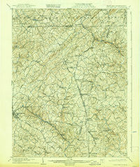
~ Westminster MD topo map, 1:62500 scale, 15 X 15 Minute, Historical, 1905, updated 1939
Westminster, Maryland, USGS topographic map dated 1905.
Includes geographic coordinates (latitude and longitude). This topographic map is suitable for hiking, camping, and exploring, or framing it as a wall map.
Printed on-demand using high resolution imagery, on heavy weight and acid free paper, or alternatively on a variety of synthetic materials.
Topos available on paper, Waterproof, Poly, or Tyvek. Usually shipping rolled, unless combined with other folded maps in one order.
- Product Number: USGS-5368590
- Free digital map download (high-resolution, GeoPDF): Westminster, Maryland (file size: 11 MB)
- Map Size: please refer to the dimensions of the GeoPDF map above
- Weight (paper map): ca. 55 grams
- Map Type: POD USGS Topographic Map
- Map Series: HTMC
- Map Verison: Historical
- Cell ID: 64434
- Scan ID: 257693
- Imprint Year: 1939
- Survey Year: 1903
- Datum: NAD
- Map Projection: Polyconic
- Map published by United States Geological Survey
- Map Language: English
- Scanner Resolution: 600 dpi
- Map Cell Name: Westminster
- Grid size: 15 X 15 Minute
- Date on map: 1905
- Map Scale: 1:62500
- Geographical region: Maryland, United States
Neighboring Maps:
All neighboring USGS topo maps are available for sale online at a variety of scales.
Spatial coverage:
Topo map Westminster, Maryland, covers the geographical area associated the following places:
- Sticks - Fenwood Heights - Roseville Heights - Sterner Heights Estates - Trenton Mill - Trident Acres - Hillside - Treelin Manor - Bixler Valley Estates - Cascade Estates - Fenby - Chazdale North - Rarjem Acres - Prettyboy Trails - Lawndale Acres - Leatherwood - Kalten Acres - Northbrook - Sharon Oaks - Green Acres - Rockbrook Village - Trenton - Lawndale - Sugar Valley - Deep Run - Eden Farms - Patapsco Woods - Haletown - Alma Meadows - Snydersburg Manor - Blue Grass Manor - Wilimot Manor - Hickory Ridge Farms - Reese Manor - Carriage Hills - Dominos Acres - Melrose - Ross Run Estates - Rockbrook Trailer Park - Adams Chance - Hidden Valley - Carroll County Trails - Dayspring Estates - Boones Meadows - Washington Court - Wine Bel Valley - Valley View - Peaceful Valley - Steeplechase - Stiltz - Country Life Estates - Allana Acres - Sullivan Heights - Bachman Mills - Benedict Woods - Washington Heights - England Estates - Armacost - Dug Hill - Manchester - Lees Mill - Meadow View - Fairmount North - Mich-Trace Estates - Tannery - Cape Hill Farms - Berrywood Village - Gunpowder Acres - Fridinger Estates - Donney Brook Farms - Sunset Way - Mountain Lake View - Foreston - Middletown Estates - Brummel - Shiloh - Village of Bachman - Alesia - Beckleysville - Topkapi - Glover Acres - White Oak Ridge - Tara Oaks - Finlandia - Aspen Run - Young Mans Fancy - Harrington - Whispering Valley - Small Crossings - Glasers Hill - Raubenstine - Happy Valley - Brothers Delight - Twin Knolls - Blackrock - Richwynn Hill - Hampstead Heights - Vangline Acres - Shirley Manor - Webers Ridge
- Map Area ID: AREA39.7539.5-77-76.75
- Northwest corner Lat/Long code: USGSNW39.75-77
- Northeast corner Lat/Long code: USGSNE39.75-76.75
- Southwest corner Lat/Long code: USGSSW39.5-77
- Southeast corner Lat/Long code: USGSSE39.5-76.75
- Northern map edge Latitude: 39.75
- Southern map edge Latitude: 39.5
- Western map edge Longitude: -77
- Eastern map edge Longitude: -76.75


