
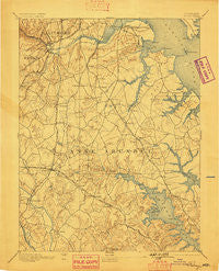
~ Relay MD topo map, 1:62500 scale, 15 X 15 Minute, Historical, 1894, updated 1898
Relay, Maryland, USGS topographic map dated 1894.
Includes geographic coordinates (latitude and longitude). This topographic map is suitable for hiking, camping, and exploring, or framing it as a wall map.
Printed on-demand using high resolution imagery, on heavy weight and acid free paper, or alternatively on a variety of synthetic materials.
Topos available on paper, Waterproof, Poly, or Tyvek. Usually shipping rolled, unless combined with other folded maps in one order.
- Product Number: USGS-5368500
- Free digital map download (high-resolution, GeoPDF): Relay, Maryland (file size: 9 MB)
- Map Size: please refer to the dimensions of the GeoPDF map above
- Weight (paper map): ca. 55 grams
- Map Type: POD USGS Topographic Map
- Map Series: HTMC
- Map Verison: Historical
- Cell ID: 61548
- Scan ID: 257643
- Imprint Year: 1898
- Survey Year: 1890
- Datum: Unstated
- Map Projection: Unstated
- Map published by United States Geological Survey
- Map Language: English
- Scanner Resolution: 600 dpi
- Map Cell Name: Relay
- Grid size: 15 X 15 Minute
- Date on map: 1894
- Map Scale: 1:62500
- Geographical region: Maryland, United States
Neighboring Maps:
All neighboring USGS topo maps are available for sale online at a variety of scales.
Spatial coverage:
Topo map Relay, Maryland, covers the geographical area associated the following places:
- Rippling Ridge - Nottingham - Danza Village - Severndale - Sun Set Knoll - Cromwell Station - Willowbrook - Meadedale - Elmhurst - Luce Creek - Fernbrook - Belvedere Heights - Robin Hood Hill - Point Somerset - Laurel Acres - Rock Anna - Wexford - Chelsea Pines - Lindamoor on the Severn - Trinity Farms - Oak Park - Fair Winds - Downs on the Severn - Oakwood Park - Arundel Mobile Village - Dunbrook - Woodlore - Omar (historical) - Saunders - Quail Ridge - Wynnewood - Devonshire - Chapelgate - Oak Ridge Manor - Guilford Manor - Sunset Beach - Academy Junction - Shipleys Choice - Selby Grove - Alberta Heights - Country Place - Turner - Glen Oban - Four Seasons Estates - Orchard Point at Piney Orchard - Stewart Corner - Suburbia - Stony Run - Stoney Hill - Walden - Garland Park - Millhausens - Grand View Park - Dreams Landing - Belvoir Farms - Arbour Manor - Linstead-on-the-Severn - Terrace View Mobile Estates - Twin Cove - Fairoaks - Tebbston - Old County Estates - The Highlands - Elvaton Acres - Brooklyn - Richardson Mews - Hillendale - Quail Run - Maple Ridge - Lions Gate - Severn Forest - Sunnyview Acres - Glenmore - Sandalwood - Cromwell Fountain - Quail Run - Blossom Hills - Lake View - Revell - Oak Landing - Cypress Creek - West Dale Park - Aspen Park - Courts of Crofton - Gambrills - Dunkeld Manor - Silva-De-Amor - Yorktown - Rosemont - Bentwoods - Summerhill Park - Stoneybrook Village - Woodside Square - Monumental - Hillside Park - Herald Harbor - Lawyers Hill - Fairfield Homes - Shipley Corner - Patuxent
- Map Area ID: AREA39.2539-76.75-76.5
- Northwest corner Lat/Long code: USGSNW39.25-76.75
- Northeast corner Lat/Long code: USGSNE39.25-76.5
- Southwest corner Lat/Long code: USGSSW39-76.75
- Southeast corner Lat/Long code: USGSSE39-76.5
- Northern map edge Latitude: 39.25
- Southern map edge Latitude: 39
- Western map edge Longitude: -76.75
- Eastern map edge Longitude: -76.5


