
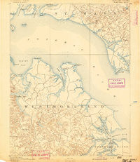
~ Piney Point MD topo map, 1:62500 scale, 15 X 15 Minute, Historical, 1892
Piney Point, Maryland, USGS topographic map dated 1892.
Includes geographic coordinates (latitude and longitude). This topographic map is suitable for hiking, camping, and exploring, or framing it as a wall map.
Printed on-demand using high resolution imagery, on heavy weight and acid free paper, or alternatively on a variety of synthetic materials.
Topos available on paper, Waterproof, Poly, or Tyvek. Usually shipping rolled, unless combined with other folded maps in one order.
- Product Number: USGS-5368444
- Free digital map download (high-resolution, GeoPDF): Piney Point, Maryland (file size: 6 MB)
- Map Size: please refer to the dimensions of the GeoPDF map above
- Weight (paper map): ca. 55 grams
- Map Type: POD USGS Topographic Map
- Map Series: HTMC
- Map Verison: Historical
- Cell ID: 61021
- Scan ID: 257599
- Survey Year: 1890
- Datum: Unstated
- Map Projection: Unstated
- Map published by United States Geological Survey
- Map Language: English
- Scanner Resolution: 600 dpi
- Map Cell Name: Piney Point
- Grid size: 15 X 15 Minute
- Date on map: 1892
- Map Scale: 1:62500
- Geographical region: Maryland, United States
Neighboring Maps:
All neighboring USGS topo maps are available for sale online at a variety of scales.
Spatial coverage:
Topo map Piney Point, Maryland, covers the geographical area associated the following places:
- Tidwells - Harryhogan - Kinsale - Callaway - Griffiths Corner - Neenah - Potomac Shores - Oldhams - Bayside - Lane Beach - Tolson - Carys Corner - McKay Beach - Palmtown - Tucker Hill - Nomini Grove - Machodoc - Meter - Belvedere Woodland - Hague - Nomini - Tall Timbers - White Point Beach - Hinnom - Piney Point - Westmoreland - Narrow Beach - Ragged Point Beach - Piney Point Shores - Breton Beach - Lanedon - Sandyland Beach - Herring Creek Estates - Dukes Retreat - Sandy Point - Valley Lee - Herring Creek - Bull Neck - Shady Harbor Shores - Acorn - Morrisons Corner - Saint George Beach - Saint George Park - Coles Point - Wilderness - Mount Holly - Grays Corner - Erica - Andover Estates - Chingville - Kremlin
- Map Area ID: AREA38.2538-76.75-76.5
- Northwest corner Lat/Long code: USGSNW38.25-76.75
- Northeast corner Lat/Long code: USGSNE38.25-76.5
- Southwest corner Lat/Long code: USGSSW38-76.75
- Southeast corner Lat/Long code: USGSSE38-76.5
- Northern map edge Latitude: 38.25
- Southern map edge Latitude: 38
- Western map edge Longitude: -76.75
- Eastern map edge Longitude: -76.5


