
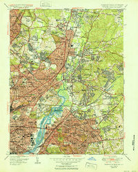
~ Washington East DC topo map, 1:24000 scale, 7.5 X 7.5 Minute, Historical, 1951
Washington East, District of Columbia, USGS topographic map dated 1951.
Includes geographic coordinates (latitude and longitude). This topographic map is suitable for hiking, camping, and exploring, or framing it as a wall map.
Printed on-demand using high resolution imagery, on heavy weight and acid free paper, or alternatively on a variety of synthetic materials.
Topos available on paper, Waterproof, Poly, or Tyvek. Usually shipping rolled, unless combined with other folded maps in one order.
- Product Number: USGS-5367476
- Free digital map download (high-resolution, GeoPDF): Washington East, District of Columbia (file size: 19 MB)
- Map Size: please refer to the dimensions of the GeoPDF map above
- Weight (paper map): ca. 55 grams
- Map Type: POD USGS Topographic Map
- Map Series: HTMC
- Map Verison: Historical
- Cell ID: 47599
- Scan ID: 256974
- Woodland Tint: Yes
- Aerial Photo Year: 1949
- Edit Year: 1949
- Survey Year: 1942
- Datum: NAD27
- Map Projection: Polyconic
- Map published by United States Geological Survey
- Map Language: English
- Scanner Resolution: 600 dpi
- Map Cell Name: Washington East
- Grid size: 7.5 X 7.5 Minute
- Date on map: 1951
- Map Scale: 1:24000
- Geographical region: District of Columbia, United States
Neighboring Maps:
All neighboring USGS topo maps are available for sale online at a variety of scales.
Spatial coverage:
Topo map Washington East, District of Columbia, covers the geographical area associated the following places:
- Avondale - Brookland - College Heights - Michigan Park Hills - Isherwood - New Hampshire Estates - Colmar Manor - Eastland Gardens - Edgewood Terrace - College Heights Estates - Langley Park - Marshall Heights - Capitol Heights - New Carrollton - Nacocktanke (historical) - East Pines - Morris Addition (historical) - Northeast Boundary - Cottage City - Riggs Park - Mayfair-Parkside - Hampshire Knolls - Tuxedo Colony - Hyattsville - Radiant Valley - Edmonston - Tuxedo - Seat Pleasant - Mount Rainier - Green Meadows - Deanwood - North Woodridge - Rives - Lewisdale - Highland Park - Bladensburg - Deanwood Park - Castle Manor - Central Northeast - Branchville - Calvert Hills - Highland - University Gardens - North Avondale - Woodlawn - Michigan Park - Kingman Park - Stafford - Walker Mill - Monastery Lot (historical) - Green Manor - Yorkshire Knolls - Bellemead - Southeast - West Riverdale - Chillum Gardens - Chillum - White House Heights - Wildercroft - Queenstown - Lakeland - Brookside Manor - College Park - Chapel Oaks - Greater Capitol Heights - North Brentwood - Clark Mills Estate Subdivision (historical) - Canonbury Square - Capitol View - Carole Highlands - North Kenilworth - Cheverly - Riverdale Hills - Landover Hills - Kentland - Greenway - Queens Chapel Manor - Riverdale Gardens - Fort Lincoln New Town - Chillum Manor - Lincoln Park - Avondale Terrace - Brentwood - East Washington Heights - Ellaville - Nacotchtanke (historical) - Hyattsville Hills - Fairmount Heights - Berwyn Heights - East Riverdale - Riverdale Heights - Kirkwood - Dodge Park - Ivy City - Kilmarock - River Terrace - Browns Corner - Landover - Berwyn - Lincoln Heights
- Map Area ID: AREA3938.875-77-76.875
- Northwest corner Lat/Long code: USGSNW39-77
- Northeast corner Lat/Long code: USGSNE39-76.875
- Southwest corner Lat/Long code: USGSSW38.875-77
- Southeast corner Lat/Long code: USGSSE38.875-76.875
- Northern map edge Latitude: 39
- Southern map edge Latitude: 38.875
- Western map edge Longitude: -77
- Eastern map edge Longitude: -76.875


