
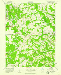
~ Upper Marlboro MD topo map, 1:24000 scale, 7.5 X 7.5 Minute, Historical, 1957, updated 1958
Upper Marlboro, Maryland, USGS topographic map dated 1957.
Includes geographic coordinates (latitude and longitude). This topographic map is suitable for hiking, camping, and exploring, or framing it as a wall map.
Printed on-demand using high resolution imagery, on heavy weight and acid free paper, or alternatively on a variety of synthetic materials.
Topos available on paper, Waterproof, Poly, or Tyvek. Usually shipping rolled, unless combined with other folded maps in one order.
- Product Number: USGS-5367434
- Free digital map download (high-resolution, GeoPDF): Upper Marlboro, Maryland (file size: 11 MB)
- Map Size: please refer to the dimensions of the GeoPDF map above
- Weight (paper map): ca. 55 grams
- Map Type: POD USGS Topographic Map
- Map Series: HTMC
- Map Verison: Historical
- Cell ID: 46415
- Scan ID: 256953
- Imprint Year: 1958
- Woodland Tint: Yes
- Aerial Photo Year: 1956
- Field Check Year: 1957
- Survey Year: 1944
- Datum: NAD27
- Map Projection: Polyconic
- Map published by United States Army Corps of Engineers
- Map Language: English
- Scanner Resolution: 600 dpi
- Map Cell Name: Upper Marlboro
- Grid size: 7.5 X 7.5 Minute
- Date on map: 1957
- Map Scale: 1:24000
- Geographical region: Maryland, United States
Neighboring Maps:
All neighboring USGS topo maps are available for sale online at a variety of scales.
Spatial coverage:
Topo map Upper Marlboro, Maryland, covers the geographical area associated the following places:
- Ritchie - Brookwood - The Woods of Marlton - Melwood Mobile Home Park - Rosaryville - Windy Oaks - North Roblee Acres - Croom - Mellwood - Forestville - Little Washington - Brown - Greenwood Manor - Williamsburg Estates - Rosaryville Estates - Rolling Acres - Wallace Estates - Woodyard - Oak Grove - Marlton - Fairgreen - D'Arcy Hills - Brookridge Manor - Westphalia - Meadows - Windsor Park - Hollaway Estates - Berry Lane - Maryvale - Coles Corner - Queensland - Roblee Acres - Westphalia Estates - Phelps - Clinton Heights - Chester Grove - Norbourne Mobile Home Park - Rolling Glen Farms - Brandywine County - Flower Village Mobile Home Park - Brock Hall - Fernwood Mobile Home Park
- Map Area ID: AREA38.87538.75-76.875-76.75
- Northwest corner Lat/Long code: USGSNW38.875-76.875
- Northeast corner Lat/Long code: USGSNE38.875-76.75
- Southwest corner Lat/Long code: USGSSW38.75-76.875
- Southeast corner Lat/Long code: USGSSE38.75-76.75
- Northern map edge Latitude: 38.875
- Southern map edge Latitude: 38.75
- Western map edge Longitude: -76.875
- Eastern map edge Longitude: -76.75


