
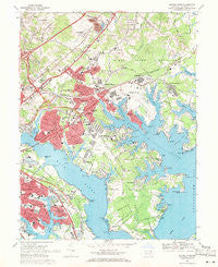
~ Middle River MD topo map, 1:24000 scale, 7.5 X 7.5 Minute, Historical, 1969, updated 1971
Middle River, Maryland, USGS topographic map dated 1969.
Includes geographic coordinates (latitude and longitude). This topographic map is suitable for hiking, camping, and exploring, or framing it as a wall map.
Printed on-demand using high resolution imagery, on heavy weight and acid free paper, or alternatively on a variety of synthetic materials.
Topos available on paper, Waterproof, Poly, or Tyvek. Usually shipping rolled, unless combined with other folded maps in one order.
- Product Number: USGS-5366752
- Free digital map download (high-resolution, GeoPDF): Middle River, Maryland (file size: 15 MB)
- Map Size: please refer to the dimensions of the GeoPDF map above
- Weight (paper map): ca. 55 grams
- Map Type: POD USGS Topographic Map
- Map Series: HTMC
- Map Verison: Historical
- Cell ID: 29090
- Scan ID: 256590
- Imprint Year: 1971
- Woodland Tint: Yes
- Aerial Photo Year: 1966
- Field Check Year: 1969
- Datum: NAD27
- Map Projection: Polyconic
- Map published by United States Geological Survey
- Map Language: English
- Scanner Resolution: 600 dpi
- Map Cell Name: Middle River
- Grid size: 7.5 X 7.5 Minute
- Date on map: 1969
- Map Scale: 1:24000
- Geographical region: Maryland, United States
Neighboring Maps:
All neighboring USGS topo maps are available for sale online at a variety of scales.
Spatial coverage:
Topo map Middle River, Maryland, covers the geographical area associated the following places:
- Poplar - Wildwood Beach - Chesterwood - Biscayne Bay Village - Wampler Village - Cape May Landing - Williams Estates - Marys Choice - Turkey Point - Silver Manor - Essexshire Gate - Cool Breeze Mobile Home Park - Essexshire - Back River - Canterbury - Rockaway Beach - Fontana Village - Peppermint Woods Mobile Home Park - Aero Acres - North Point - Eagle Nest - Len Mar Community - Edgewater - Hartland Village - Stansbury Estates - Battle Grove - Country Ridge - Essex - Middleborough - Mansfield Woods - Marine Oak Village - Woodward Square - Goldentree - Hopkins Landing - Glenmar Manor - Middle River - Airport Beach (historical) - Eastern Terrace - Bowleys Quarters - Sleepy Hollow Mobile Home Park - Inverness - Middlesex - Glenwood Trailer Park - Shady Oaks - Briarwood Estate - Carrollwood - Cape May Beach - Stemmers Run - Porters Park - Wilson Point - Chesaco Park - Breezy Point Beach - Mars Estates - Urbanwood - Oakdale - Carrollwood Manor - Back River Highlands - Dundee Village - Charlesmont - Village of Pawner - Berkfield - Hawthorne - Evergreen Park - Beachwood - Fox Ridge Manor - Whitemarsh Estates - Glenmar - Grange - Sue Creek Landing - Victory Villa Gardens - Port Cherry Gardens Farm - Riverwood Park - Ken Lee Mobile Home Courts - Gray Haven - Long Beach Estates - Hyde Park - Victory Villa - Grimesdale - Josenhans - Gray Manor - Island View Beach - Holly Beach - Bengies - Maple Crest - Barrington - Lynnhurst - Hartland Run - North Point Village - Ballard Gardens - Carroll Island - Nottingham - Cedar Beach - Rossville - Kings Court - Golden Ring
- Map Area ID: AREA39.37539.25-76.5-76.375
- Northwest corner Lat/Long code: USGSNW39.375-76.5
- Northeast corner Lat/Long code: USGSNE39.375-76.375
- Southwest corner Lat/Long code: USGSSW39.25-76.5
- Southeast corner Lat/Long code: USGSSE39.25-76.375
- Northern map edge Latitude: 39.375
- Southern map edge Latitude: 39.25
- Western map edge Longitude: -76.5
- Eastern map edge Longitude: -76.375


