
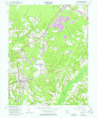
~ La Plata MD topo map, 1:24000 scale, 7.5 X 7.5 Minute, Historical, 1956, updated 1977
La Plata, Maryland, USGS topographic map dated 1956.
Includes geographic coordinates (latitude and longitude). This topographic map is suitable for hiking, camping, and exploring, or framing it as a wall map.
Printed on-demand using high resolution imagery, on heavy weight and acid free paper, or alternatively on a variety of synthetic materials.
Topos available on paper, Waterproof, Poly, or Tyvek. Usually shipping rolled, unless combined with other folded maps in one order.
- Product Number: USGS-5366592
- Free digital map download (high-resolution, GeoPDF): La Plata, Maryland (file size: 10 MB)
- Map Size: please refer to the dimensions of the GeoPDF map above
- Weight (paper map): ca. 55 grams
- Map Type: POD USGS Topographic Map
- Map Series: HTMC
- Map Verison: Historical
- Cell ID: 24145
- Scan ID: 256505
- Imprint Year: 1977
- Woodland Tint: Yes
- Photo Revision Year: 1974
- Aerial Photo Year: 1974
- Survey Year: 1944
- Datum: NAD27
- Map Projection: Polyconic
- Map published by United States Army Corps of Engineers
- Map Language: English
- Scanner Resolution: 600 dpi
- Map Cell Name: La Plata
- Grid size: 7.5 X 7.5 Minute
- Date on map: 1956
- Map Scale: 1:24000
- Geographical region: Maryland, United States
Neighboring Maps:
All neighboring USGS topo maps are available for sale online at a variety of scales.
Spatial coverage:
Topo map La Plata, Maryland, covers the geographical area associated the following places:
- Hunters Ridge - Pine Hill Estates - Hampshire - Pheasant Farm - Warrlinda - Maxwelton - Oakland Estates - Kings Grant - White Plains - Spring Valley - Morgans Ridge - Hickory Ridge - Radcliffe Estates - Hope Acres - Wakefield - Willow Gate - Billingsley Park - Glen Oak - Lakewood Estates - Kings Manor South - Clarks Run - White Plains Village - Beantown - Old Colony - Roosevelt Heights - Newtown - Brookwood Acres - Oakwood - West White Plains - Turkey Hill - Huntington Townhouses - Mount Carmel Woods - Oak Knolls - Westlake Village - Quailwood - Capitol Estates - Haldane - Ellenwood - Middletown - Charowood - The Meadows - Newtown Estates - Wood Haven Park - Huntington - White Plains Mobile Home Park - Jennie Run Estates - Saint Charles - Brynwood Farm Estates - Oak Hill Estates - Carrington - Brice - Forest Grove - Lyons Corner - Cleveland Park Estates - Mariellen Park - Kerrick Manor - White Station - Springhill - Waldorf - Green Acres Estates - Bannister - Deerwood - Northgate - La Plata - Dorchester - Kent Square - Hillwood - Halley Estates - Rosewick - Spring Oak Estates
- Map Area ID: AREA38.62538.5-77-76.875
- Northwest corner Lat/Long code: USGSNW38.625-77
- Northeast corner Lat/Long code: USGSNE38.625-76.875
- Southwest corner Lat/Long code: USGSSW38.5-77
- Southeast corner Lat/Long code: USGSSE38.5-76.875
- Northern map edge Latitude: 38.625
- Southern map edge Latitude: 38.5
- Western map edge Longitude: -77
- Eastern map edge Longitude: -76.875


