
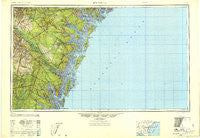
~ Brunswick GA topo map, 1:250000 scale, 1 X 2 Degree, Historical, 1946, updated 1948
Brunswick, Georgia, USGS topographic map dated 1946.
Includes geographic coordinates (latitude and longitude). This topographic map is suitable for hiking, camping, and exploring, or framing it as a wall map.
Printed on-demand using high resolution imagery, on heavy weight and acid free paper, or alternatively on a variety of synthetic materials.
Topos available on paper, Waterproof, Poly, or Tyvek. Usually shipping rolled, unless combined with other folded maps in one order.
- Product Number: USGS-5365364
- Free digital map download (high-resolution, GeoPDF): Brunswick, Georgia (file size: 17 MB)
- Map Size: please refer to the dimensions of the GeoPDF map above
- Weight (paper map): ca. 55 grams
- Map Type: POD USGS Topographic Map
- Map Series: HTMC
- Map Verison: Historical
- Cell ID: 68694
- Scan ID: 707248
- Imprint Year: 1948
- Woodland Tint: Yes
- Aerial Photo Year: 1944
- Survey Year: 1945
- Datum: NAD27
- Map Projection: Transverse Mercator
- Planimetric: Yes
- Shaded Relief map: Yes
- Map published by United States Army Corps of Engineers
- Map published by United States Army
- Map published by United States Department of War
- Map Language: English
- Scanner Resolution: 508 dpi
- Map Cell Name: Brunswick
- Grid size: 1 X 2 Degree
- Date on map: 1946
- Map Scale: 1:250000
- Geographical region: Georgia, United States
Neighboring Maps:
All neighboring USGS topo maps are available for sale online at a variety of scales.
Spatial coverage:
Topo map Brunswick, Georgia, covers the geographical area associated the following places:
- Pennick - Ardick - Mount Herman - Noble - Grimball Park - Sweet Hill - Ogeechee Farms - Myrtle Grove - Gum Branch - Evergreen - East End - Burton Terrace - Wilmington - Island Retreat - Saint Simons Island - Windward Acres - Jewtown - Woodwind South - Jenks (historical) - Belle Point Estates - Mount Pleasant - Southern Pines Mobile Home Village - College Park - Cox - Burroughs - Cedar Hammock - Bowen - Lynhurst - Lulaton - Glynn Camp - Nahunta - Ashmore - Lida (historical) - Nicholsonville - Middle Place - Drum Point Landing - Hickory Bluff - McIntosh - Crossroads - Brickston - Altamaha Park - Bradwell Estates - Hallwood Homes - Alsennias Trailer Park - Country Lane Mobile Home Park - Parkersburg - Fancy Hall - Burnett - Richmond Hill - Alton (historical) - Birdford (historical) - Red Bluff - Deer Run Estates - Belfast - Glendale Gardens - Beverly Shores - Lynn - Tupelo Trail - Thornhill Mobile Home Park - Darien - Welwood - Olmstead - Wildwood - O Neal - Pinewood Estates - White Bluff - Thomas Landing - Marshwood at the Landings - Azalea Gardens - Transvilla Mobile Home Park - Jamaica - Cinder Hill - Thalmann - Spring Bluff - Cherokee Village - Drawdy - Island View - Fort Stewart - Mount Pleasant - Herbert Heights - Oakhurst - Wormsloe - Pointe South - Kicklighter (historical) - Georgetown - Cedar Grove - Lotts (historical) - Jesup - Mallory Park - Blythe Island - Odessa - Bakers Crossing - Roderick (historical) - Wilmington Park - Kings Wood - Ponderosa Village Mobile Home Park - Smiley Crossroads - Pinehurst - Berkshire Woods - Salter
- Map Area ID: AREA3231-82-80
- Northwest corner Lat/Long code: USGSNW32-82
- Northeast corner Lat/Long code: USGSNE32-80
- Southwest corner Lat/Long code: USGSSW31-82
- Southeast corner Lat/Long code: USGSSE31-80
- Northern map edge Latitude: 32
- Southern map edge Latitude: 31
- Western map edge Longitude: -82
- Eastern map edge Longitude: -80


