
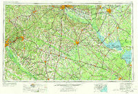
~ Augusta GA topo map, 1:250000 scale, 1 X 2 Degree, Historical, 1957, updated 1973
Augusta, Georgia, USGS topographic map dated 1957.
Includes geographic coordinates (latitude and longitude). This topographic map is suitable for hiking, camping, and exploring, or framing it as a wall map.
Printed on-demand using high resolution imagery, on heavy weight and acid free paper, or alternatively on a variety of synthetic materials.
Topos available on paper, Waterproof, Poly, or Tyvek. Usually shipping rolled, unless combined with other folded maps in one order.
- Product Number: USGS-5365348
- Free digital map download (high-resolution, GeoPDF): Augusta, Georgia (file size: 20 MB)
- Map Size: please refer to the dimensions of the GeoPDF map above
- Weight (paper map): ca. 55 grams
- Map Type: POD USGS Topographic Map
- Map Series: HTMC
- Map Verison: Historical
- Cell ID: 68654
- Scan ID: 247829
- Imprint Year: 1973
- Woodland Tint: Yes
- Photo Revision Year: 1969
- Aerial Photo Year: 1955
- Edit Year: 1969
- Field Check Year: 1957
- Datum: Unstated
- Map Projection: Transverse Mercator
- Map published by United States Geological Survey
- Map Language: English
- Scanner Resolution: 600 dpi
- Map Cell Name: Augusta
- Grid size: 1 X 2 Degree
- Date on map: 1957
- Map Scale: 1:250000
- Geographical region: Georgia, United States
Neighboring Maps:
All neighboring USGS topo maps are available for sale online at a variety of scales.
Spatial coverage:
Topo map Augusta, Georgia, covers the geographical area associated the following places:
- Cowden - Saint George - Sardinia - Eastview - Sheridan Estates - Spring Branch (historical) - Pineview Acres - Sixty Six - Whites Pond Crossroad - Reynold - Oakland - Pecanway Terrace - Scottsville - Swansea - Johnsville - Swinton - Summer View - Bruner - Alexander - Jedburg - Bolen Town - Ashleigh - Lynwood - Meadowbrook - Macedon - Wilson Crossroads - Chaparral Ranches - Dixie Crossing - Clubhouse Crossroads - Briarcliff - Brownsville - Spiderweb - Aiken Estates - Highland Village - White Oak - Deerfield - Sweetwater - Totness - Lakewood - Dominion Hills - Kalmia Landing - Cordova - Foxville - Old Church - Knollwood - The Cottage - Windtree - Trinity Cross Roads - Boulder Bluff - Asbury (historical) - Martin - Tiller Circle - Galaxy - Kalmia Hills - Leawood - Smyly - Bonnie Glen - Lazy Acres Estates - Malta - Pennington Acres - Mobleys Crossroads - Sugar Hill - Aiken Heights - Pine Hill - Gatewood - Warington - Walker - Deer Ridge Farms - Lakewood - Oakridge - Felderville - Starmount - Locklair (historical) - Thomas Station - Hunters Glen - Deerwood - Augusta - Chaffee (historical) - New Holland Crossroads - Beckridge Park - Bull Station - Shiloh - Fersners - Woodhill Estates - Foxborough - Sandlewood - Barclay Estates - Seloc - Blacks - Woodsen - Baskin Hills - Midfield - Summerville - Orangewood - Archdale - Millett - Marden Ranchettes - Pleasant Grove - Silver Lake - Eagle Point
- Map Area ID: AREA3433-82-80
- Northwest corner Lat/Long code: USGSNW34-82
- Northeast corner Lat/Long code: USGSNE34-80
- Southwest corner Lat/Long code: USGSSW33-82
- Southeast corner Lat/Long code: USGSSE33-80
- Northern map edge Latitude: 34
- Southern map edge Latitude: 33
- Western map edge Longitude: -82
- Eastern map edge Longitude: -80


