
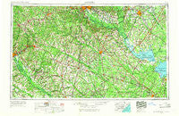
~ Augusta GA topo map, 1:250000 scale, 1 X 2 Degree, Historical, 1957, updated 1966
Augusta, Georgia, USGS topographic map dated 1957.
Includes geographic coordinates (latitude and longitude). This topographic map is suitable for hiking, camping, and exploring, or framing it as a wall map.
Printed on-demand using high resolution imagery, on heavy weight and acid free paper, or alternatively on a variety of synthetic materials.
Topos available on paper, Waterproof, Poly, or Tyvek. Usually shipping rolled, unless combined with other folded maps in one order.
- Product Number: USGS-5365346
- Free digital map download (high-resolution, GeoPDF): Augusta, Georgia (file size: 21 MB)
- Map Size: please refer to the dimensions of the GeoPDF map above
- Weight (paper map): ca. 55 grams
- Map Type: POD USGS Topographic Map
- Map Series: HTMC
- Map Verison: Historical
- Cell ID: 68654
- Scan ID: 247828
- Imprint Year: 1966
- Woodland Tint: Yes
- Aerial Photo Year: 1957
- Edit Year: 1966
- Field Check Year: 1957
- Datum: Unstated
- Map Projection: Transverse Mercator
- Map published by United States Army Corps of Engineers
- Map published by United States Army
- Map Language: English
- Scanner Resolution: 600 dpi
- Map Cell Name: Augusta
- Grid size: 1 X 2 Degree
- Date on map: 1957
- Map Scale: 1:250000
- Geographical region: Georgia, United States
Neighboring Maps:
All neighboring USGS topo maps are available for sale online at a variety of scales.
Spatial coverage:
Topo map Augusta, Georgia, covers the geographical area associated the following places:
- Elloree - Pine Forest - Gerwil Acres - Land of the Lakes - Ruffin - Oak Park - Savannah Terrace - Hibernia - Marshall Heights - Carolina Gardens - Whites Pond Crossroad - Merritts Bridge (historical) - Lotts Crossroads - Pigeon Bay (historical) - Orangeburg Manor - Swearingen (historical) - West Ridge - Cross - Summerton - Ward - Edgefield Heights - Edisto - Sardinia - Waynor (historical) - Seiglers Crossroads - Gable - Walnut Creek - Clemson Terrace - Mackay Subdivision - Tompkins Cross Roads - Four Holes - Lakewood - Oakwood - Wiles Crossroads - Inabinetts (historical) - Edistone (historical) - Gloverville - Seloc - Creekmoor - Hilda - Madison - Sharpes Hill - Gregg Park - Hammond Crossroads - Pembrook - Lazy Acres Estates - Bradleyville - Cordova - Deer Ridge Farms - Crafton (historical) - Pinewood - Davis Crossroads - Forest Acres - Parkway Place - Stone Gap - Langley - Priceville - Hillside - Dry Branch - Shadblow - Gilbert - Luther (historical) - Telfair Woods - Bon Air Terrace - Allendale - Brookhaven Estates - Sherwood Forest - Deerfield - Cherryvale - North Brookdale - Connors (historical) - Midway - Woodland Heights - Reynold - Cotton Hill - Dorchee (historical) - Windwood - Moss Pond (historical) - Saint Julian - East Sunway Knolls - The Village Subdivision - South Congaree - Belser Crossroads - Windtree - Happytown - North - Westcliff - Pine Hill - Fox Bank (historical) - Saint Matthews - Tahoma - Augusta - Clubhouse Crossroads - Idlewood - Wrenwood - Barr Crossing - Home Acres - Glenn Village - Brick Yard Trace - Rennie (historical)
- Map Area ID: AREA3433-82-80
- Northwest corner Lat/Long code: USGSNW34-82
- Northeast corner Lat/Long code: USGSNE34-80
- Southwest corner Lat/Long code: USGSSW33-82
- Southeast corner Lat/Long code: USGSSE33-80
- Northern map edge Latitude: 34
- Southern map edge Latitude: 33
- Western map edge Longitude: -82
- Eastern map edge Longitude: -80


