
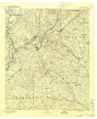
~ Gainesville GA topo map, 1:125000 scale, 30 X 30 Minute, Historical, 1891, updated 1942
Gainesville, Georgia, USGS topographic map dated 1891.
Includes geographic coordinates (latitude and longitude). This topographic map is suitable for hiking, camping, and exploring, or framing it as a wall map.
Printed on-demand using high resolution imagery, on heavy weight and acid free paper, or alternatively on a variety of synthetic materials.
Topos available on paper, Waterproof, Poly, or Tyvek. Usually shipping rolled, unless combined with other folded maps in one order.
- Product Number: USGS-5365238
- Free digital map download (high-resolution, GeoPDF): Gainesville, Georgia (file size: 8 MB)
- Map Size: please refer to the dimensions of the GeoPDF map above
- Weight (paper map): ca. 55 grams
- Map Type: POD USGS Topographic Map
- Map Series: HTMC
- Map Verison: Historical
- Cell ID: 65534
- Scan ID: 247750
- Imprint Year: 1942
- Survey Year: 1889
- Datum: Unstated
- Map Projection: Polyconic
- Map published by United States Geological Survey
- Map Language: English
- Scanner Resolution: 600 dpi
- Map Cell Name: Gainesville
- Grid size: 30 X 30 Minute
- Date on map: 1891
- Map Scale: 1:125000
- Geographical region: Georgia, United States
Neighboring Maps:
All neighboring USGS topo maps are available for sale online at a variety of scales.
Spatial coverage:
Topo map Gainesville, Georgia, covers the geographical area associated the following places:
- Le Dan - Raoul - Beaver Pond - Lake Watch - North Banks Cove - Apple Valley - Pinecrest Heights - Thompsons Mill - Twin Rivers - Broadnax - Klondike - Waverly Way - Laurel Hills - Algernon (historical) - Eaglewood - Wild Fern - Tyner - Country Club Gardens - Hog Mountain - Devane - Trudy - Westside - Woodland Springs - Balus Creek - Waterford - Mountain View - Ridgewood - Price - Byers - Meadowood - Timberidge - Clarks Bridge Place - Oscarville - Sagefield - River Point - Hollingsworth - Pond Fork (historical) - Gay Lan - Barrett - Hammer - Woodhaven Downs - River Run - Sardis Estates - Holly Springs - Looper Lake - Pine Point - Tanner - Strickland Heights - Wahoo Valley - Heather Heights - Moore - Thurmack - Kemp - Flat Creek - Timberwood Estates - Chapman - Scotts Cove - Cherrywood - Tapawingo - Pleasant Brook - Morning Side Hills - Gravel Springs - Habersham Hills - Whitmire - Olde Federal Pointe - Tanner Mill - McClure - Chestnut Oak Hills - Sardis Shores - Green Meadows - Pebble Brook - Lakeland Heights - Southgate - Murrayville - Oakwood - Forest Park - Grapevine (historical) - Beverly Hills - Atlas Circle - Green Hills - Gillsville - Pendergrass - Cameron Point - Holland - Hayes - Cains Courthouse (historical) - Pine Hills - Chicopee - Chestnut Mountain - Brookwood - Sagamore - Wilbanks Corner - Sunset Heights - Springlake Estates - Rabbitown - Botany Woods - Chattahoochee Place - Greenway - Cedar Hill - Lanier North Woods
- Map Area ID: AREA34.534-84-83.5
- Northwest corner Lat/Long code: USGSNW34.5-84
- Northeast corner Lat/Long code: USGSNE34.5-83.5
- Southwest corner Lat/Long code: USGSSW34-84
- Southeast corner Lat/Long code: USGSSE34-83.5
- Northern map edge Latitude: 34.5
- Southern map edge Latitude: 34
- Western map edge Longitude: -84
- Eastern map edge Longitude: -83.5


