
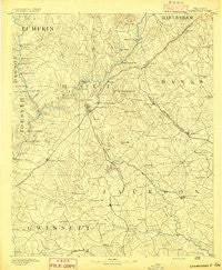
~ Gainesville GA topo map, 1:125000 scale, 30 X 30 Minute, Historical, 1891
Gainesville, Georgia, USGS topographic map dated 1891.
Includes geographic coordinates (latitude and longitude). This topographic map is suitable for hiking, camping, and exploring, or framing it as a wall map.
Printed on-demand using high resolution imagery, on heavy weight and acid free paper, or alternatively on a variety of synthetic materials.
Topos available on paper, Waterproof, Poly, or Tyvek. Usually shipping rolled, unless combined with other folded maps in one order.
- Product Number: USGS-5365232
- Free digital map download (high-resolution, GeoPDF): Gainesville, Georgia (file size: 7 MB)
- Map Size: please refer to the dimensions of the GeoPDF map above
- Weight (paper map): ca. 55 grams
- Map Type: POD USGS Topographic Map
- Map Series: HTMC
- Map Verison: Historical
- Cell ID: 65534
- Scan ID: 247747
- Survey Year: 1889
- Datum: Unstated
- Map Projection: Unstated
- Map published by United States Geological Survey
- Map Language: English
- Scanner Resolution: 600 dpi
- Map Cell Name: Gainesville
- Grid size: 30 X 30 Minute
- Date on map: 1891
- Map Scale: 1:125000
- Geographical region: Georgia, United States
Neighboring Maps:
All neighboring USGS topo maps are available for sale online at a variety of scales.
Spatial coverage:
Topo map Gainesville, Georgia, covers the geographical area associated the following places:
- Holiday Heights - Strickland Heights - Bretton Woods - Lake Haven - Pinecrest Heights - Cool Springs Forest - Ridgewood - Marlow - Broadnax - Brookton - Bellton - Beard - Clermont - Wayne - Cascade Woods - Lula - Gilleland - Chattahoochee Place - Baldwin - Oak Harbor - Evergreen Heights - Venture Cove - Whelchel - Cherokee Hills - Morning Side Hills - Spring View Acres - Blackshear Place - Hidden Harbor - Colony South - Forest Park - New Holland - Hollingsworth - Wahoo Forest - Chicopee - The Bluffs - Pebble Brook - Mundys Point - Hughesboro (historical) - Glades - Olde Federal Pointe - Greystone - Hillcroft Heights - Gillsville - Camellia Heights - Halfway (historical) - Gower Springs (historical) - Thurmack - Bentwood - Northcliff Colony - Raintree East - Longview - Oscarville - Scoutland - McClure - Fox Hollow - North Banks Cove - Chestatee North - Gainesville - Absalom (historical) - Tapawingo - River Point - Leisure Lake - The Circles - Gainesville Mills - Lanier Northwest - Holly Springs - Talassee (historical) - Marlette Heights - Hoschton - Fox Trace - Apple Valley - Barnes - Meadowood - Spout Spring Crossroads - Lanier North Woods - Hargrove - Northlake - Woodhaven Downs - Balus Creek - Squirrel Creek - Dry Pond - Blueberry Hills - Holland - Pine Ridge Point - Holland - Chestnut Mountain - Shady Lane - Summer Point - Sugar Hill - Arcade - Thyatira - White Sulphur Springs - Surf Side Club Estates - Pine Haven - Dunagan - Pine Forest - Mountain View - Woodlake - Sunset Heights - Rock Creek Estates
- Map Area ID: AREA34.534-84-83.5
- Northwest corner Lat/Long code: USGSNW34.5-84
- Northeast corner Lat/Long code: USGSNE34.5-83.5
- Southwest corner Lat/Long code: USGSSW34-84
- Southeast corner Lat/Long code: USGSSE34-83.5
- Northern map edge Latitude: 34.5
- Southern map edge Latitude: 34
- Western map edge Longitude: -84
- Eastern map edge Longitude: -83.5


