
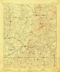
~ Cartersville GA topo map, 1:125000 scale, 30 X 30 Minute, Historical, 1896, updated 1914
Cartersville, Georgia, USGS topographic map dated 1896.
Includes geographic coordinates (latitude and longitude). This topographic map is suitable for hiking, camping, and exploring, or framing it as a wall map.
Printed on-demand using high resolution imagery, on heavy weight and acid free paper, or alternatively on a variety of synthetic materials.
Topos available on paper, Waterproof, Poly, or Tyvek. Usually shipping rolled, unless combined with other folded maps in one order.
- Product Number: USGS-5365174
- Free digital map download (high-resolution, GeoPDF): Cartersville, Georgia (file size: 7 MB)
- Map Size: please refer to the dimensions of the GeoPDF map above
- Weight (paper map): ca. 55 grams
- Map Type: POD USGS Topographic Map
- Map Series: HTMC
- Map Verison: Historical
- Cell ID: 65145
- Scan ID: 247700
- Imprint Year: 1914
- Survey Year: 1887
- Datum: Unstated
- Map Projection: Unstated
- Map published by United States Geological Survey
- Map Language: English
- Scanner Resolution: 600 dpi
- Map Cell Name: Cartersville
- Grid size: 30 X 30 Minute
- Date on map: 1896
- Map Scale: 1:125000
- Geographical region: Georgia, United States
Neighboring Maps:
All neighboring USGS topo maps are available for sale online at a variety of scales.
Spatial coverage:
Topo map Cartersville, Georgia, covers the geographical area associated the following places:
- Bolivar - Aylmer (historical) - Kellogg Creek - Stamp Creek (historical) - Pine Hill - Kingridge Estates - Independence Walk - Edgewood Estates - Laurel Hills - Dewey Crossroads - Bobo - Cedar Mill Crossing - Kennesaw Acres - Sugar Hill (historical) - Harris Woods - Baker Ridge - Oak Creek Estates - Lakeside Hills - Picketts Plantation - Pine Log - Beasley Gap - Acworth Meadows - Cobb Place Manor - Mars Hill Downs - Bartow - Stir Up Manor - Payne - Countryside Estates - Aubrey - Waleska - Blackwood - Lily Pond - McCollum Acres - Greenbriar - Allatoona Heights - Oakland Heights - Cardinal Woods - Allatoona Quarters - Spring Valley Mobile Home Park - Owens Meadows - Nowlin Station - Valley Hill Estates - Sonoraville - Joshua Landing - Summit (historical) - Sherwood Forest - Skyridge - Bells Ferry Place - Cherokee South - Logan Trace - Nowlin Estates - Wood Glen - Brookwood - Blackwell Chase - Holly Spring - Halls - East Boxwood Estates - Oak Grove - Mission Estates - McGuire Heights - Belaire - Cherokee Mobile Home Park - Timberlake North - Ludville - Jamerson Forest - Snow Springs - Shadowood Mobile Home Park - Allatoona Bay - Sturbridge - Colony Woods - Walker Hills - Crowville - The Woods at Colony Crossing - Sumpter Ridge - Shellman (historical) - Chunn Estates - Indian Valley Estates - Jerusalem - North Highland - Don (historical) - Hills-A-Rolling - County Manor - Giles Crossing - Buena Vista - Stilesboro - Cherokee Forest - Salem Woods - Tyson Estates - Hunt Club - Plantation Walk - Univeter - Burnt Hickory Ridge Estates - Kingridge North - Stockwood Estates - McGinnis (historical) - Wildwood - Ladds - Heritage Place - Country Village - Picketts Creek
- Map Area ID: AREA34.534-85-84.5
- Northwest corner Lat/Long code: USGSNW34.5-85
- Northeast corner Lat/Long code: USGSNE34.5-84.5
- Southwest corner Lat/Long code: USGSSW34-85
- Southeast corner Lat/Long code: USGSSE34-84.5
- Northern map edge Latitude: 34.5
- Southern map edge Latitude: 34
- Western map edge Longitude: -85
- Eastern map edge Longitude: -84.5


