
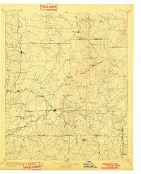
~ Cartersville GA topo map, 1:125000 scale, 30 X 30 Minute, Historical, 1896, updated 1901
Cartersville, Georgia, USGS topographic map dated 1896.
Includes geographic coordinates (latitude and longitude). This topographic map is suitable for hiking, camping, and exploring, or framing it as a wall map.
Printed on-demand using high resolution imagery, on heavy weight and acid free paper, or alternatively on a variety of synthetic materials.
Topos available on paper, Waterproof, Poly, or Tyvek. Usually shipping rolled, unless combined with other folded maps in one order.
- Product Number: USGS-5365172
- Free digital map download (high-resolution, GeoPDF): Cartersville, Georgia (file size: 7 MB)
- Map Size: please refer to the dimensions of the GeoPDF map above
- Weight (paper map): ca. 55 grams
- Map Type: POD USGS Topographic Map
- Map Series: HTMC
- Map Verison: Historical
- Cell ID: 65145
- Scan ID: 247699
- Imprint Year: 1901
- Survey Year: 1887
- Datum: Unstated
- Map Projection: Unstated
- Map published by United States Geological Survey
- Map Language: English
- Scanner Resolution: 600 dpi
- Map Cell Name: Cartersville
- Grid size: 30 X 30 Minute
- Date on map: 1896
- Map Scale: 1:125000
- Geographical region: Georgia, United States
Neighboring Maps:
All neighboring USGS topo maps are available for sale online at a variety of scales.
Spatial coverage:
Topo map Cartersville, Georgia, covers the geographical area associated the following places:
- Kennesaw Acres - Parkerosa - East Boxwood Estates - Stamp Creek (historical) - Junta - The Woods at Colony Crossing - Allatoona Pass - Cross Roads - The Arbors - Fairmount - County Manor - Braswell Corners - Talmadge - Greyfield North - Pleasant Valley - Breeze Hill Estates - Euharlee - Sherwood Forest - Bascombs Springs - Mission Estates - Brookwood - Sequoyah Estates - Shellman (historical) - Baker Ridge - Plantation Walk - Jamerson Forest - Yacht Club Estates - Mission Hills - Owens Meadows - Hinton - Don (historical) - McCallie - Vestavia Estates - The Crossroads - Double Springs (historical) - Arden Lake - Atco - Southfork - South Canton - Woodstock Station - Pages Mobile Home Park - Independence Walk - Ashley Forest - Bobo - Green Hills Estates - Colony Woods - Country Creek - Hickory Forest - Fields Landing - Adairsville - Savanna Place - Rodgers - Roving Hills Estates - Grassdale - Terrell Heights - Blackwell Chase - Victoria Landing - Westfork - Mars Hill Downs - Lakewood Heights - Kellogg Creek North - Oak Hill - Mountain Ridge Estates - Heritage Farms - Pine Hill - Allatoona - Bells Ferry Place - Summer Trace - Salacoa - Cartersville - Skyridge - Indian Village - Homestead Acres - Conyers Estates - Gum Springs - Emerald Willows - Allatoona Quarters - Lake Pointe - Falcon Shores - Falcon Hills - Payne Mobile Home Park - Bowls (historical) - Eastgate Mobile Home Park - Allatoona Beach - Ludville - Nowlin Station - Harvest Estates - Rydal - Yarbroughs Mill - Pinehurst - Etowah Mills - Cash - Valley Hill Estates - Greely - Modern Living Mobile Home Park - Powell Station - Five Forks - Tyson Estates - Sumpter Ridge - Hamby Place
- Map Area ID: AREA34.534-85-84.5
- Northwest corner Lat/Long code: USGSNW34.5-85
- Northeast corner Lat/Long code: USGSNE34.5-84.5
- Southwest corner Lat/Long code: USGSSW34-85
- Southeast corner Lat/Long code: USGSSE34-84.5
- Northern map edge Latitude: 34.5
- Southern map edge Latitude: 34
- Western map edge Longitude: -85
- Eastern map edge Longitude: -84.5


