
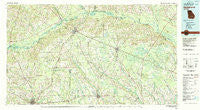
~ Hazlehurst GA topo map, 1:100000 scale, 30 X 60 Minute, Historical, 1979, updated 1980
Hazlehurst, Georgia, USGS topographic map dated 1979.
Includes geographic coordinates (latitude and longitude). This topographic map is suitable for hiking, camping, and exploring, or framing it as a wall map.
Printed on-demand using high resolution imagery, on heavy weight and acid free paper, or alternatively on a variety of synthetic materials.
Topos available on paper, Waterproof, Poly, or Tyvek. Usually shipping rolled, unless combined with other folded maps in one order.
- Product Number: USGS-5365102
- Free digital map download (high-resolution, GeoPDF): Hazlehurst, Georgia (file size: 27 MB)
- Map Size: please refer to the dimensions of the GeoPDF map above
- Weight (paper map): ca. 55 grams
- Map Type: POD USGS Topographic Map
- Map Series: HTMC
- Map Verison: Historical
- Cell ID: 67654
- Scan ID: 247645
- Imprint Year: 1980
- Woodland Tint: Yes
- Aerial Photo Year: 1974
- Edit Year: 1979
- Datum: NAD27
- Map Projection: Universal Transverse Mercator
- Map published by United States Geological Survey
- Map Language: English
- Scanner Resolution: 600 dpi
- Map Cell Name: Hazlehurst
- Grid size: 30 X 60 Minute
- Date on map: 1979
- Map Scale: 1:100000
- Geographical region: Georgia, United States
Neighboring Maps:
All neighboring USGS topo maps are available for sale online at a variety of scales.
Spatial coverage:
Topo map Hazlehurst, Georgia, covers the geographical area associated the following places:
- Five Points - Paceville (historical) - Quinn (historical) - Grays Landing - Saginaw - Lambright - Ritch - Pine Forest - Tallahassee - Huffer - Roper - Bingham (historical) - Lees Trailer Park - Relee - Blystonel - Maysie (historical) - Tetlow - Sapps Still - Clay Homes - Wheaton - Bethel - Weatherly Park - Brooker - Holt Homes - Upton - Broxton - Pine Grove - Warrick Homes - Johnsonville (historical) - K'Ville - McNatt Falls - Cobbville - Odum - Sessoms - Hazlehurst - Zion - Speer Homes - Ellis (historical) - Kirkland - Douglas - Lumber City - Jacksonville - Davis - Neily - Lotts - Pridgen - Oak Park - Chatterton - Spring Branch - Tison - Altamaha - Piney Grove - Baxley - English Eddy - Cherokee Hills - Denton - Cannafax Mobile Home Park - West Green - Brentwood - Workmore - Coffee - Cook Heights - Falling Rocks - New Lacy - Goldsmith (historical) - Bushnell - Satilla - Orico (historical) - Surrency - Lehigh - Guysie - Pines Mobile Home Park - Phillipi - Graham - Snipesville - Cedarpark - Eason Bluff - Rockingham - Prentiss - Bassville - Alma - Baker Homes - McTier - Shady Acres - Holmesville - Nicholls
- Map Area ID: AREA3231.5-83-82
- Northwest corner Lat/Long code: USGSNW32-83
- Northeast corner Lat/Long code: USGSNE32-82
- Southwest corner Lat/Long code: USGSSW31.5-83
- Southeast corner Lat/Long code: USGSSE31.5-82
- Northern map edge Latitude: 32
- Southern map edge Latitude: 31.5
- Western map edge Longitude: -83
- Eastern map edge Longitude: -82


