
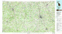
~ Griffin GA topo map, 1:100000 scale, 30 X 60 Minute, Historical, 1979, updated 1980
Griffin, Georgia, USGS topographic map dated 1979.
Includes geographic coordinates (latitude and longitude). This topographic map is suitable for hiking, camping, and exploring, or framing it as a wall map.
Printed on-demand using high resolution imagery, on heavy weight and acid free paper, or alternatively on a variety of synthetic materials.
Topos available on paper, Waterproof, Poly, or Tyvek. Usually shipping rolled, unless combined with other folded maps in one order.
- Product Number: USGS-5365098
- Free digital map download (high-resolution, GeoPDF): Griffin, Georgia (file size: 34 MB)
- Map Size: please refer to the dimensions of the GeoPDF map above
- Weight (paper map): ca. 55 grams
- Map Type: POD USGS Topographic Map
- Map Series: HTMC
- Map Verison: Historical
- Cell ID: 67613
- Scan ID: 247641
- Imprint Year: 1980
- Woodland Tint: Yes
- Aerial Photo Year: 1976
- Edit Year: 1979
- Datum: NAD27
- Map Projection: Universal Transverse Mercator
- Map published by United States Geological Survey
- Map Language: English
- Scanner Resolution: 600 dpi
- Map Cell Name: Griffin
- Grid size: 30 X 60 Minute
- Date on map: 1979
- Map Scale: 1:100000
- Geographical region: Georgia, United States
Neighboring Maps:
All neighboring USGS topo maps are available for sale online at a variety of scales.
Spatial coverage:
Topo map Griffin, Georgia, covers the geographical area associated the following places:
- Rover - Unity Grove - Farmdale (historical) - Woodcraft - Harp - Magnolia Farms - Smiths Chapel - Trimble - Bear Creek Landing - Stephens Crossroad - Jolly - Gay - Ridgelake - Meadow Run - Fetlock Meadows - Treillage - The Retreat - Valdo (historical) - Smiths Crossroads - Groveland - Creekside Crossing Estates - Mountville - Tyrone - Whitesburg - Smoke Rise Plantation - Broom Hall - Smith City - White Oak - Camp Creek Estates - Dunaway Gardens - Mundys Mill - West Hampton - Willow Bend - Brookwood - Lynhaven - Lamont (historical) - Briarwood Acres - Stevens Forest - Aberdeen - Burnham Woods - Yates - Caruso - Tapestry - Patillo - Handy - Lone Oak - Bottoms - Rest (historical) - Rolling Meadows Estates - Goggins - Towaliga (historical) - Johnstonville - East Griffin - Lowry - Fischers Crossroad - Chanticleer - Oakdale - Peachtree Villas - Turin - Hammett Acres - Corinth - Edgewater - Windsong - Fayette Acres - Experiment - Beverly Manor - Harrisonville - Revere (historical) - Locust Grove - Fayetteville - Weldons Crossroads - Pine Hills - Esmond - Reidsboro - Alps - Sunny Side - The Marks - Haralson - Liberty Hill - Clover - Peeks Crossing - Highland Mills - Lake Cindy Estates - Luella - Gregory Estates - Hastings - Milner Crossroads - Braelinn Courts - Cambridge Estates - Senoia - Woolsey Creek Plantation - Valleywood Corners - Thompson Crossroad - Raintree East - Barker - Meadowview Mobile Home Park - Spooner Ridge - Stallings Crossroad - Creek Subdivision - Forest Estates
- Map Area ID: AREA33.533-85-84
- Northwest corner Lat/Long code: USGSNW33.5-85
- Northeast corner Lat/Long code: USGSNE33.5-84
- Southwest corner Lat/Long code: USGSSW33-85
- Southeast corner Lat/Long code: USGSSE33-84
- Northern map edge Latitude: 33.5
- Southern map edge Latitude: 33
- Western map edge Longitude: -85
- Eastern map edge Longitude: -84


