
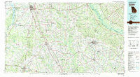
~ Cordele GA topo map, 1:100000 scale, 30 X 60 Minute, Historical, 1981, updated 1982
Cordele, Georgia, USGS topographic map dated 1981.
Includes geographic coordinates (latitude and longitude). This topographic map is suitable for hiking, camping, and exploring, or framing it as a wall map.
Printed on-demand using high resolution imagery, on heavy weight and acid free paper, or alternatively on a variety of synthetic materials.
Topos available on paper, Waterproof, Poly, or Tyvek. Usually shipping rolled, unless combined with other folded maps in one order.
- Product Number: USGS-5365092
- Free digital map download (high-resolution, GeoPDF): Cordele, Georgia (file size: 25 MB)
- Map Size: please refer to the dimensions of the GeoPDF map above
- Weight (paper map): ca. 55 grams
- Map Type: POD USGS Topographic Map
- Map Series: HTMC
- Map Verison: Historical
- Cell ID: 67338
- Scan ID: 247637
- Imprint Year: 1982
- Woodland Tint: Yes
- Aerial Photo Year: 1974
- Edit Year: 1981
- Datum: NAD27
- Map Projection: Universal Transverse Mercator
- Map published by United States Geological Survey
- Map Language: English
- Scanner Resolution: 600 dpi
- Map Cell Name: Cordele
- Grid size: 30 X 60 Minute
- Date on map: 1981
- Map Scale: 1:100000
- Geographical region: Georgia, United States
Neighboring Maps:
All neighboring USGS topo maps are available for sale online at a variety of scales.
Spatial coverage:
Topo map Cordele, Georgia, covers the geographical area associated the following places:
- Lulaville - Bethel - Osierfield - Raines - Marshall - Rebecca - Pindertown (historical) - Sumner - Bridges - Bedgood - Waterloo - Statham Shoals - Bowens Mill - Blue Spring (historical) - Sibbie - High Springs (historical) - Abbeville - Felder (historical) - Arabi - Wenona - Shinglers (historical) - Coney - Sylvester - Hardin - Ocilla - Inaha - Kramer - Thomas Acres - Acree - Pateville - Sharon - Red Bluff - Browning - Doles - East Crisp - Sycamore - Westwood - Hoganville (historical) - Camp Sherwood - Artesia (historical) - Fitzgerald - Worth - McKenzie - Chula - Hatley - Willingham (historical) - Mossy Oaks - Five Points - Cuffietown - China Hill - Armboy - Copeland - Poplar Hill - Daphne (historical) - New York (historical) - Double Run - Temperance - Owensboro - Rhine - Woodcrest Subdivision - Shingler - Milldale (historical) - Coverdale - Hobby - Lands Crossroads - Arp - Acorn Pond - Aultmans (historical) - Brighton - Terrell - Sibley - Ashburn - Rochelle - Red Rock - Abba - Mystic - Listonia - Warwick - Williford (historical) - Gammage - Dakota - Musselwhite - Deerfield Farm Estates - Poulan - San Barnard (historical) - Holt - Seville - Wray - Cold Springs (historical) - Harding - Sunsweet - Ambrose - Pinetta - Pitts - Cobb - Isabella - East Dougherty - Queensland - Oakfield - Cordele
- Map Area ID: AREA3231.5-84-83
- Northwest corner Lat/Long code: USGSNW32-84
- Northeast corner Lat/Long code: USGSNE32-83
- Southwest corner Lat/Long code: USGSSW31.5-84
- Southeast corner Lat/Long code: USGSSE31.5-83
- Northern map edge Latitude: 32
- Southern map edge Latitude: 31.5
- Western map edge Longitude: -84
- Eastern map edge Longitude: -83


