
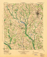
~ Statesboro GA topo map, 1:62500 scale, 15 X 15 Minute, Historical, 1943
Statesboro, Georgia, USGS topographic map dated 1943.
Includes geographic coordinates (latitude and longitude). This topographic map is suitable for hiking, camping, and exploring, or framing it as a wall map.
Printed on-demand using high resolution imagery, on heavy weight and acid free paper, or alternatively on a variety of synthetic materials.
Topos available on paper, Waterproof, Poly, or Tyvek. Usually shipping rolled, unless combined with other folded maps in one order.
- Product Number: USGS-5364996
- Free digital map download (high-resolution, GeoPDF): Statesboro, Georgia (file size: 9 MB)
- Map Size: please refer to the dimensions of the GeoPDF map above
- Weight (paper map): ca. 55 grams
- Map Type: POD USGS Topographic Map
- Map Series: HTMC
- Map Verison: Historical
- Cell ID: 62938
- Scan ID: 247568
- Woodland Tint: Yes
- Survey Year: 1919
- Datum: NAD27
- Map Projection: Polyconic
- Map published by United States Army Corps of Engineers
- Map published by United States Army
- Map published by United States Department of War
- Map Language: English
- Scanner Resolution: 600 dpi
- Map Cell Name: Statesboro
- Grid size: 15 X 15 Minute
- Date on map: 1943
- Map Scale: 1:62500
- Geographical region: Georgia, United States
Neighboring Maps:
All neighboring USGS topo maps are available for sale online at a variety of scales.
Spatial coverage:
Topo map Statesboro, Georgia, covers the geographical area associated the following places:
- Greenbriar - Foxlake - Forest Heights - Pine Needle Hills - Westbrooke - Hillside Mobile Home Park - Pulaski - Stadium Club - Saddlecreek - Irongate - Statesboro - Nevils - Westchester - Wolf Pen Mobile Home Park - Forest Hills - Rushing Mobile Home Park - Pine Forest - Country Squire - Horseshoe Bend - Enal (historical) - Woodland Mobile Estates - Northwood - Stadium Walk - Country Club Hills - Deerfield - Northlake - Somerset - Belair Estates - Johnsons Mobile Court - Georgian Walk - Pine Cove - Sussex Commons - Georgia Southern - Quail Run - Ramblewood East - Oakcrest - Colfax (historical) - Pate Place - Inglewood - Woodlawn Terrace - Kingswood - Northpoint Mobile Home Park - Greenhaven Mobile Home Park - Huntington - Excelsior - Greenwood - Register - Bird Mobile Home Park - Country Club Estates - New Hope - Adabelle - Lynn Haven Estates - Edgewood Acres - Olde Towne - Jimps - Hazelwood - Sherwood Forest - Lakeview Estates - Parish - Eagle Court
- Map Area ID: AREA32.532.25-82-81.75
- Northwest corner Lat/Long code: USGSNW32.5-82
- Northeast corner Lat/Long code: USGSNE32.5-81.75
- Southwest corner Lat/Long code: USGSSW32.25-82
- Southeast corner Lat/Long code: USGSSE32.25-81.75
- Northern map edge Latitude: 32.5
- Southern map edge Latitude: 32.25
- Western map edge Longitude: -82
- Eastern map edge Longitude: -81.75


