
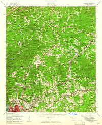
~ Ellerslie GA topo map, 1:62500 scale, 15 X 15 Minute, Historical, 1955, updated 1961
Ellerslie, Georgia, USGS topographic map dated 1955.
Includes geographic coordinates (latitude and longitude). This topographic map is suitable for hiking, camping, and exploring, or framing it as a wall map.
Printed on-demand using high resolution imagery, on heavy weight and acid free paper, or alternatively on a variety of synthetic materials.
Topos available on paper, Waterproof, Poly, or Tyvek. Usually shipping rolled, unless combined with other folded maps in one order.
- Product Number: USGS-5364790
- Free digital map download (high-resolution, GeoPDF): Ellerslie, Georgia (file size: 12 MB)
- Map Size: please refer to the dimensions of the GeoPDF map above
- Weight (paper map): ca. 55 grams
- Map Type: POD USGS Topographic Map
- Map Series: HTMC
- Map Verison: Historical
- Cell ID: 53831
- Scan ID: 247430
- Imprint Year: 1961
- Woodland Tint: Yes
- Aerial Photo Year: 1954
- Edit Year: 1955
- Field Check Year: 1955
- Survey Year: 1950
- Datum: NAD27
- Map Projection: Polyconic
- Map published by United States Army Corps of Engineers
- Map Language: English
- Scanner Resolution: 600 dpi
- Map Cell Name: Ellerslie
- Grid size: 15 X 15 Minute
- Date on map: 1955
- Map Scale: 1:62500
- Geographical region: Georgia, United States
Neighboring Maps:
All neighboring USGS topo maps are available for sale online at a variety of scales.
Spatial coverage:
Topo map Ellerslie, Georgia, covers the geographical area associated the following places:
- Brookview Estates - Beaver Run - Westgate - Caroline Park - Glenns - Sunshine Acres - Kingston - Fox Chapel - Williamsburg - Camelot - Ranch Forest - Laurel Hills - Charter Oaks - Kenwood - Double Churches - Crescent Ridge - Cataula - Lyn Hills - Ellerslie - Highland Pines - Commonwealth (historical) - Arrowhead Estates - Innsbrook - Sears Woods - Weems Valley - Lake Oliver Estates - Midland - Hillbrook Estates - Lokey Estates - Fortson Terrace - Kingsboro - Maridale Estates - Foxfire - Spring Valley - Dover Hills - Cascade Hills - Schatulga - Hunters Court - Leesburg - Ossahatchie - Morningside - Twin Chapel - Allendale - Rehobeth - Farmington - Beverly Heights - Flat Rock - Flat Rock Estates - Willow Bend - North Oaks - Peppertree - Fortson - Tulakes - Victory Heights - Kirkwood - Lakeshore - Ogletree Woods - Barin - Spring Lake - Shenandoah Forest - Castlewood - Lincoln Hills - Windsor Park - Cheshire Valley - Crystal Valley - Hidden Hills - Gordydale - Nankipooh - Foxrun - Beallwoods - Bayard (historical) - Candlestick - North Kingston - Georgian Hills - Hearthstone - Wayne Terrace - Mulberry Grove - Turntime Crossroads - Autumnridge - Moores Forest - Brookstone - Gentian - Timberdale - Northgate
- Map Area ID: AREA32.7532.5-85-84.75
- Northwest corner Lat/Long code: USGSNW32.75-85
- Northeast corner Lat/Long code: USGSNE32.75-84.75
- Southwest corner Lat/Long code: USGSSW32.5-85
- Southeast corner Lat/Long code: USGSSE32.5-84.75
- Northern map edge Latitude: 32.75
- Southern map edge Latitude: 32.5
- Western map edge Longitude: -85
- Eastern map edge Longitude: -84.75


