
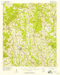
~ Doerun GA topo map, 1:62500 scale, 15 X 15 Minute, Historical, 1956, updated 1958
Doerun, Georgia, USGS topographic map dated 1956.
Includes geographic coordinates (latitude and longitude). This topographic map is suitable for hiking, camping, and exploring, or framing it as a wall map.
Printed on-demand using high resolution imagery, on heavy weight and acid free paper, or alternatively on a variety of synthetic materials.
Topos available on paper, Waterproof, Poly, or Tyvek. Usually shipping rolled, unless combined with other folded maps in one order.
- Product Number: USGS-5364776
- Free digital map download (high-resolution, GeoPDF): Doerun, Georgia (file size: 9 MB)
- Map Size: please refer to the dimensions of the GeoPDF map above
- Weight (paper map): ca. 55 grams
- Map Type: POD USGS Topographic Map
- Map Series: HTMC
- Map Verison: Historical
- Cell ID: 53486
- Scan ID: 247421
- Imprint Year: 1958
- Woodland Tint: Yes
- Aerial Photo Year: 1955
- Field Check Year: 1956
- Datum: NAD27
- Map Projection: Polyconic
- Map published by United States Geological Survey
- Map Language: English
- Scanner Resolution: 600 dpi
- Map Cell Name: Doerun
- Grid size: 15 X 15 Minute
- Date on map: 1956
- Map Scale: 1:62500
- Geographical region: Georgia, United States
Neighboring Maps:
All neighboring USGS topo maps are available for sale online at a variety of scales.
Spatial coverage:
Topo map Doerun, Georgia, covers the geographical area associated the following places:
- Gintown (historical) - Parkerville - Sigsbee - Gordy - Tempy - Doerun - Minton - New Elm - Anderson City - Liberty Hill - Groveland Estates - Dry Creek Subdivision - Terrace (historical) - Alfords - Indian Cove (historical) - Powelltown - Minnesota - Crestwood - Pritchetts - Livingston - Bridgeboro - Ticknor
- Map Area ID: AREA31.531.25-84-83.75
- Northwest corner Lat/Long code: USGSNW31.5-84
- Northeast corner Lat/Long code: USGSNE31.5-83.75
- Southwest corner Lat/Long code: USGSSW31.25-84
- Southeast corner Lat/Long code: USGSSE31.25-83.75
- Northern map edge Latitude: 31.5
- Southern map edge Latitude: 31.25
- Western map edge Longitude: -84
- Eastern map edge Longitude: -83.75


