
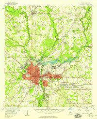
~ Albany GA topo map, 1:62500 scale, 15 X 15 Minute, Historical, 1956, updated 1958
Albany, Georgia, USGS topographic map dated 1956.
Includes geographic coordinates (latitude and longitude). This topographic map is suitable for hiking, camping, and exploring, or framing it as a wall map.
Printed on-demand using high resolution imagery, on heavy weight and acid free paper, or alternatively on a variety of synthetic materials.
Topos available on paper, Waterproof, Poly, or Tyvek. Usually shipping rolled, unless combined with other folded maps in one order.
- Product Number: USGS-5364650
- Free digital map download (high-resolution, GeoPDF): Albany, Georgia (file size: 8 MB)
- Map Size: please refer to the dimensions of the GeoPDF map above
- Weight (paper map): ca. 55 grams
- Map Type: POD USGS Topographic Map
- Map Series: HTMC
- Map Verison: Historical
- Cell ID: 50389
- Scan ID: 247332
- Imprint Year: 1958
- Woodland Tint: Yes
- Aerial Photo Year: 1956
- Survey Year: 1956
- Datum: NAD27
- Map Projection: Polyconic
- Map published by United States Geological Survey
- Map Language: English
- Scanner Resolution: 600 dpi
- Map Cell Name: Albany
- Grid size: 15 X 15 Minute
- Date on map: 1956
- Map Scale: 1:62500
- Geographical region: Georgia, United States
Neighboring Maps:
All neighboring USGS topo maps are available for sale online at a variety of scales.
Spatial coverage:
Topo map Albany, Georgia, covers the geographical area associated the following places:
- Eastgate - Garden Hill - Whispering Pines - West Highland - Flintland - Pecan Haven - Audubon - Isabella Heights - Winterwood - Cleveland Heights - Gloriana - Sunny Acres - Elon Village - Ragsdale - Colonial Village - Butler Subdivision - Florary - Brookwood - Oakdale - Westwood - Mockingbird Estates - Coachman Park - Avert Acres - Avondale - Catalina Beach Estates - Mayfair - Azalea Terrace - Five Points - Powell Place - Relswood Terrace - North Slappy Heights - Southwind - Sandalwood - Evergreen - Oak Grove Estates Mobile Home Park - Murray Hill - Lakeside - Saint Andrews - Stocks (historical) - Northend - Albany - Nutview (historical) - Radium Springs - Pineview - Pecan Terrace - Riverview - Shackleford Place - Valley Park - Gordon Heights - Avondale Acres - Town and Country Acres - Stocks - Harmon Heights - Century - Green Acres - Road Pecan Park - Hillside - West Town - Kalmon - Westhampton - Clearview - Palmyra Homes - River Road - Leesburg - Woodland Acres - Hillcrest - Palmyra Heights - Fulford Heights - Airport Subdivision - Lake Park - Cedar Heights - Eugemar - Colonial Place - Highland Park - Hotalihuyana (historical) - Stroms - Fairfield - Rolling Groves - Forest Park - Dawson Heights - Beloit - Plantation Hills - Walters - Hinds - Edgewood - Malone - Northside - East Albany - Flintside - Lincoln Heights - Paradise Village Mobile Home Park - Brentwood - Turner City - Northend Addition - Dixieland - Rawson Park - Gailshar Gardens - Palmyra - Dosaga - Westgate
- Map Area ID: AREA31.7531.5-84.25-84
- Northwest corner Lat/Long code: USGSNW31.75-84.25
- Northeast corner Lat/Long code: USGSNE31.75-84
- Southwest corner Lat/Long code: USGSSW31.5-84.25
- Southeast corner Lat/Long code: USGSSE31.5-84
- Northern map edge Latitude: 31.75
- Southern map edge Latitude: 31.5
- Western map edge Longitude: -84.25
- Eastern map edge Longitude: -84


