
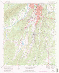
~ Rome South GA topo map, 1:24000 scale, 7.5 X 7.5 Minute, Historical, 1968, updated 1986
Rome South, Georgia, USGS topographic map dated 1968.
Includes geographic coordinates (latitude and longitude). This topographic map is suitable for hiking, camping, and exploring, or framing it as a wall map.
Printed on-demand using high resolution imagery, on heavy weight and acid free paper, or alternatively on a variety of synthetic materials.
Topos available on paper, Waterproof, Poly, or Tyvek. Usually shipping rolled, unless combined with other folded maps in one order.
- Product Number: USGS-5363770
- Free digital map download (high-resolution, GeoPDF): Rome South, Georgia (file size: 8 MB)
- Map Size: please refer to the dimensions of the GeoPDF map above
- Weight (paper map): ca. 55 grams
- Map Type: POD USGS Topographic Map
- Map Series: HTMC
- Map Verison: Historical
- Cell ID: 38498
- Scan ID: 650725
- Imprint Year: 1986
- Woodland Tint: Yes
- Visual Version Number: 2
- Photo Revision Year: 1985
- Aerial Photo Year: 1981
- Edit Year: 1985
- Field Check Year: 1968
- Datum: NAD27
- Map Projection: Polyconic
- Map published by United States Geological Survey
- Map Language: English
- Scanner Resolution: 508 dpi
- Map Cell Name: Rome South
- Grid size: 7.5 X 7.5 Minute
- Date on map: 1968
- Map Scale: 1:24000
- Geographical region: Georgia, United States
Neighboring Maps:
All neighboring USGS topo maps are available for sale online at a variety of scales.
Spatial coverage:
Topo map Rome South, Georgia, covers the geographical area associated the following places:
- Ridgewood Estates - Six Mile - Reeseburg - Horseleg Estates - New Rome - Ridgedale - Rosemont Park - Woodpin Estates - Robealou Acres - Nottingham Estates - Twickenham - Gaither Park - Atlanta Junction - Boozeville - Saddle Mountain - Silvermont - Forrest Heights - Merry Acres - River Ridge - Maplewood Square - Castle Cove - Silver Creek - Radio Springs - Callier Springs Heights - River Place - Rivermont - John Graham Homes - Chulio Hills - Horseshoe Bend - Lindale - Chapel Hill
- Map Area ID: AREA34.2534.125-85.25-85.125
- Northwest corner Lat/Long code: USGSNW34.25-85.25
- Northeast corner Lat/Long code: USGSNE34.25-85.125
- Southwest corner Lat/Long code: USGSSW34.125-85.25
- Southeast corner Lat/Long code: USGSSE34.125-85.125
- Northern map edge Latitude: 34.25
- Southern map edge Latitude: 34.125
- Western map edge Longitude: -85.25
- Eastern map edge Longitude: -85.125


