
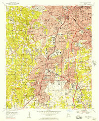
~ East Point GA topo map, 1:24000 scale, 7.5 X 7.5 Minute, Historical, 1954, updated 1957
East Point, Georgia, USGS topographic map dated 1954.
Includes geographic coordinates (latitude and longitude). This topographic map is suitable for hiking, camping, and exploring, or framing it as a wall map.
Printed on-demand using high resolution imagery, on heavy weight and acid free paper, or alternatively on a variety of synthetic materials.
Topos available on paper, Waterproof, Poly, or Tyvek. Usually shipping rolled, unless combined with other folded maps in one order.
- Product Number: USGS-5361630
- Free digital map download (high-resolution, GeoPDF): East Point, Georgia (file size: 20 MB)
- Map Size: please refer to the dimensions of the GeoPDF map above
- Weight (paper map): ca. 55 grams
- Map Type: POD USGS Topographic Map
- Map Series: HTMC
- Map Verison: Historical
- Cell ID: 42350
- Scan ID: 245623
- Imprint Year: 1957
- Woodland Tint: Yes
- Aerial Photo Year: 1952
- Field Check Year: 1954
- Datum: NAD27
- Map Projection: Polyconic
- Map published by United States Geological Survey
- Map Language: English
- Scanner Resolution: 600 dpi
- Map Cell Name: Southwest Atlanta
- Grid size: 7.5 X 7.5 Minute
- Date on map: 1954
- Map Scale: 1:24000
- Geographical region: Georgia, United States
Neighboring Maps:
All neighboring USGS topo maps are available for sale online at a variety of scales.
Spatial coverage:
Topo map East Point, Georgia, covers the geographical area associated the following places:
- Mountain View - Fort McPherson - Sylvan Hills - Adams Park - Forest Hills Mobile Home Park - Joel Chandler Harris Homes - Plunket Town - Orchard Knob - West End - Browns Mill - Cheney (historical) - Cooks Crossing - Jamestown Court - Cascade Heights - Red Wing Cove - Roseland - Hammond Park - Coxs Crossing - Capitol View - East Point - Castilian Heights - West End - Gilbert Gardens - Haasville (historical) - Maxwelton - Sun Valley - West End Park - Mechanicsville - Oak Forest - Golden Acres - Greenwood Trailer Park - Eagan Park - Lakewood Heights - Elmwood - Peoplestown - Hapeville - Knott (historical) - Pine Grove Trailer Park - College Park - Summerhill - Rosedale Heights - Atlanta - Forrest Park - Park South - Capitol Homes
- Map Area ID: AREA33.7533.625-84.5-84.375
- Northwest corner Lat/Long code: USGSNW33.75-84.5
- Northeast corner Lat/Long code: USGSNE33.75-84.375
- Southwest corner Lat/Long code: USGSSW33.625-84.5
- Southeast corner Lat/Long code: USGSSE33.625-84.375
- Northern map edge Latitude: 33.75
- Southern map edge Latitude: 33.625
- Western map edge Longitude: -84.5
- Eastern map edge Longitude: -84.375


